Back Veianen ALS ویاندن AZB Віяндэн Byelorussian Віяндэн BE-X-OLD Вианден Bulgarian Vianden Catalan Vianden (munisipyo) CEB Vianden Danish Vianden German Vianden DIQ
Vianden
Veianen, Veinen | |
|---|---|
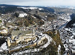
 Vianden from above | |
 Map of Luxembourg with Vianden highlighted in orange, and the canton in dark red | |
| Coordinates: 49°54′N 6°12′E / 49.9°N 6.2°E | |
| Country | |
| Canton | Vianden |
| Government | |
| • Mayor | François Weyrich |
| Area | |
• Total | 9.67 km2 (3.73 sq mi) |
| • Rank | 96th of 100 |
| Highest elevation | 515 m (1,690 ft) |
| • Rank | 15th of 100 |
| Lowest elevation | 198 m (650 ft) |
| • Rank | 24th of 100 |
| Population (2024) | |
• Total | 2,221 |
| • Rank | 77th of 100 |
| • Density | 230/km2 (590/sq mi) |
| • Rank | 35th of 100 |
| Time zone | UTC+1 (CET) |
| • Summer (DST) | UTC+2 (CEST) |
| LAU 2 | LU0000903 |
| Website | vianden.lu |
 | |
| Click on the map for a fullscreen view | |
Vianden (Luxembourgish: Veianen [ˈfɑɪɑnən] ⓘ or (locally) Veinen [ˈfɑɪnən]) is a commune with town status in the Éislek region, north-eastern Luxembourg, with a population of 2,203 as of 2023. It is part of the canton of the same name. Vianden lies on the Our river, near the border between Luxembourg and Germany. It is known for the Vianden Castle.
© MMXXIII Rich X Search. We shall prevail. All rights reserved. Rich X Search

