Back Corvo (Açores) Catalan Вила ду Корву CE Corvo (munisipyo) CEB Vila do Corvo German Βίλα ντο Κόρβο Greek Vila do Corvo Spanish Corvo (Açores) French 빌라두코르부 Korean Vila do Korvas Lithuanian Corvo, Azores Malay
Vila do Corvo | |
|---|---|
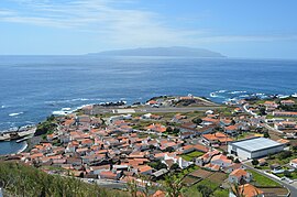
 Vila do Corvo, as seen from Portão lookout, including Aerodrome and settlement | |
 Location of the municipality of Corvo in the archipelago of the Azores | |
| Coordinates: 39°40′22″N 31°6′52″W / 39.67278°N 31.11444°W | |
| Country | |
| Auton. region | Azores |
| Island | Corvo |
| Established | Settlement: c. 1475–1503 Parish: c. 1674 Town/Municipality: June 20, 1832 |
| Government | |
| • President | Manuel das Pedras Rita |
| Area | |
| • Total | 17.11 km2 (6.61 sq mi) |
| Elevation | 36 m (118 ft) |
| Population (2011) | |
| • Total | 430 |
| • Density | 25/km2 (65/sq mi) |
| Time zone | UTC−01:00 (AZOT) |
| • Summer (DST) | UTC±00:00 (AZOST) |
| Postal code | 9980-024 |
| Area code | (+351) 292 XX XX XX |
| Patron | Nossa Senhora dos Milagres |
| Local holiday | June 20 |
| Website | http://www.cm-corvo.pt |
Vila do Corvo (Portuguese pronunciation: [ˈkoɾvu] ) is the smallest municipality in the Portuguese archipelago of the Azores, constituting the island of Corvo in its entirety. With a population of 430 in 2011,[1] it is the least populated of the Portuguese municipalities, and the only Portuguese municipality, by law, without a civil parish (freguesia, the smallest administrative unit in Portugal). Its area is 17.11 square kilometres (6.61 sq mi).[2]
Vila do Corvo has at times been incorrectly referred to as Vila Nova do Corvo. The village, the unique agglomeration on the island of Corvo, is constructed of small homes located along narrow roadways and alleys rising along the hills of the southern one-third of the island. The coastal area of the village is dominated by the Corvo Aerodrome and ports linking the community to the outside world.
- ^ Instituto Nacional de Estatística
- ^ Eurostat Archived October 7, 2012, at the Wayback Machine
© MMXXIII Rich X Search. We shall prevail. All rights reserved. Rich X Search

