Back Waikato AN إقليم وايكاتو Arabic جيهة وايكاتو ARY Waikato BAN Вайката (рэгіён) Byelorussian Уайкато (регион) Bulgarian Waikato Catalan Waikato (rehiyon) CEB Waikato (Region) German Waikato (regiono) Esperanto
Waikato
Waikato | |
|---|---|
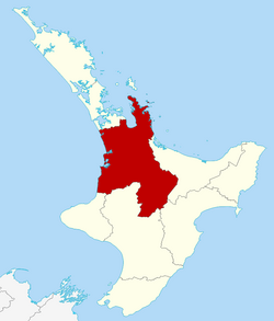
 Waikato within the North Island, New Zealand | |
| Country | New Zealand |
| Seat | Hamilton City |
| Government | |
| • Type | Regional council |
| • Body | Waikato Regional Council |
| • Chair | Pamela Storey[1] |
| • Deputy chair | Bruce Clarkson |
| Area | |
| • Land | 23,901.09 km2 (9,228.26 sq mi) |
| Population (June 2023)[4] | |
| • Total | 522,600 |
| GDP | |
| • Total | NZ$ 32.558 billion (2021) |
| • Per capita | NZ$ 63,713 (2021) |
| HDI (2021) | 0.923[6] very high · 8th |
| Website | www |

Waikato (/ˈwaɪkɑːtɔː/) is a region of the upper North Island of New Zealand. It covers the Waikato District, Waipa District, Matamata-Piako District, South Waikato District and Hamilton City, as well as Hauraki, Coromandel Peninsula, the northern King Country, much of the Taupō District, and parts of the Rotorua Lakes District.[7] It is governed by the Waikato Regional Council.
The region stretches from Coromandel Peninsula in the north, to the north-eastern slopes of Mount Ruapehu in the south, and spans the North Island from the west coast, through the Waikato and Hauraki to Coromandel Peninsula on the east coast. Broadly, the extent of the region is the Waikato River catchment. Other major catchments are those of the Waihou, Piako, Awakino and Mokau rivers. The region is bounded by Auckland on the north, Bay of Plenty on the east, Hawke's Bay on the south-east, and Manawatū-Whanganui and Taranaki on the south. Waikato Region is the fourth largest region in the country in area and population:[8] It has a land area of 23,901.09 km2 (9,228.26 sq mi) and a population of 522,600 (June 2023).[4]
The region encompasses all or part of eleven territorial authorities, the most of any region of New Zealand. It is centred on the Waikato which consists of Waikato District, Matamata-Piako District, Waipa District, South Waikato District and Hamilton City.[7] In descending order of land area the eleven territorial authorities are Taupō District (part), Waikato District, Waitomo District (part), Thames-Coromandel District, Ōtorohanga District, South Waikato District, Matamata-Piako District, Waipa District, Hauraki District, Rotorua Lakes District (part), and Hamilton City.
- ^ "Waikato Regional Council chair and deputy selected". Waikato Regional Council. 27 October 2022.
- ^ "Your Councillors". Waikato Regional Council. Retrieved 2 September 2020.
- ^ Cite error: The named reference
Areawas invoked but never defined (see the help page). - ^ a b "Subnational population estimates (RC, SA2), by age and sex, at 30 June 1996-2023 (2023 boundaries)". Statistics New Zealand. Retrieved 25 October 2023. (regional councils); "Subnational population estimates (TA, SA2), by age and sex, at 30 June 1996-2023 (2023 boundaries)". Statistics New Zealand. Retrieved 25 October 2023. (territorial authorities); "Subnational population estimates (urban rural), by age and sex, at 30 June 1996-2023 (2023 boundaries)". Statistics New Zealand. Retrieved 25 October 2023. (urban areas)
- ^ "Regional gross domestic product: Year ended March 2022". Statistics New Zealand. 24 March 2023. Retrieved 4 April 2023.
- ^ "Sub-national HDI - Area Database - Global Data Lab". hdi.globaldatalab.org. Retrieved 18 February 2023.
- ^ a b Swarbrick, Nancy (3 June 2010). "Waikato region – Overview". Te Ara – the Encyclopedia of New Zealand. Archived from the original on 27 November 2011. Retrieved 10 July 2011.
- ^ "About the Waikato region". Waikato Regional Council. Archived from the original on 20 April 2011. Retrieved 11 May 2011.
© MMXXIII Rich X Search. We shall prevail. All rights reserved. Rich X Search