Back Waitara (lungsod) CEB Waitara (Neuseeland) German Waitara French Waitara, Sealainn Nuadh Scots/Gaelic ワイタラ Japanese Waitara, New Zealand Malay Waitara Polish
Waitara | |
|---|---|
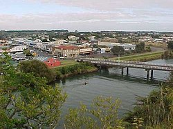
 Waitara and the Waitara River | |
 | |
| Coordinates: 38°59′45″S 174°13′59″E / 38.99583°S 174.23306°E | |
| Country | New Zealand |
| Region | Taranaki Region |
| Territorial authority | New Plymouth District |
| Ward |
|
| Community | Waitara Community |
| Electorates | |
| Government | |
| • Territorial Authority | New Plymouth District Council |
| • Regional council | Taranaki Regional Council |
| Area | |
| • Total | 6.09 km2 (2.35 sq mi) |
| Population (June 2023)[2] | |
| • Total | 7,550 |
| • Density | 1,200/km2 (3,200/sq mi) |
| Postcode(s) | 4320 |

Waitara is a town in the northern part of the Taranaki region of the North Island of New Zealand. Waitara is located just off State Highway 3, 15 kilometres (9.3 mi) northeast of New Plymouth.
Waitara was the site of the outbreak of the Taranaki Wars in 1860 following the attempted purchase of land for British settlers from its Māori owners. Disputes over land that was subsequently confiscated by the Government continue to this day.

There are several different stories regarding the origin of the name Waitara. One is that it was originally Whai-tara – "path of the dart" – so named because Whare Matangi followed the path of a dart to find his father Ngarue. Another is that Turi named it from his wide stride when crossing the water of the river. Another is that Turi named it Waitarangia because the coldness of the water affected his skin. Yet another is that it means "mountain stream". In 1867 the settlement was named Raleigh, after Sir Walter Raleigh. It reverted to its former name with the establishment of the borough of Waitara in 1904.
- ^ Cite error: The named reference
Areawas invoked but never defined (see the help page). - ^ "Subnational population estimates (RC, SA2), by age and sex, at 30 June 1996-2023 (2023 boundaries)". Statistics New Zealand. Retrieved 25 October 2023. (regional councils); "Subnational population estimates (TA, SA2), by age and sex, at 30 June 1996-2023 (2023 boundaries)". Statistics New Zealand. Retrieved 25 October 2023. (territorial authorities); "Subnational population estimates (urban rural), by age and sex, at 30 June 1996-2023 (2023 boundaries)". Statistics New Zealand. Retrieved 25 October 2023. (urban areas)
© MMXXIII Rich X Search. We shall prevail. All rights reserved. Rich X Search