Back مقاطعة والاس (كانساس) Arabic Wallace County, Kansas BAR Уолъс (окръг, Канзас) Bulgarian ৱালাসে কাউন্টি, ক্যানসাস BPY Wallace Gông (Kansas) CDO Уоллес (гуо, Канзас) CE Wallace County CEB Wallace County Czech Wallace County, Kansas Welsh Wallace County German
Wallace County | |
|---|---|
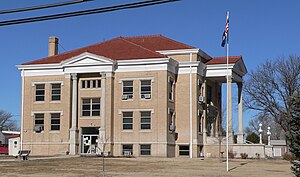
 Wallace County Courthouse in Sharon Springs (2010) | |
 Location within the U.S. state of Kansas | |
 Kansas's location within the U.S. | |
| Coordinates: 38°45′52″N 101°34′33″W / 38.7644°N 101.5758°W | |
| Country | |
| State | |
| Founded | 1868 |
| Named for | W. H. L. Wallace |
| Seat | Sharon Springs |
| Largest city | Sharon Springs |
| Area | |
| • Total | 914 sq mi (2,370 km2) |
| • Land | 914 sq mi (2,370 km2) |
| • Water | 0.05 sq mi (0.1 km2) 0.01% |
| Population | |
| • Total | 1,512 |
| • Estimate (2021)[2] | 1,508 |
| • Density | 1.7/sq mi (0.7/km2) |
| Time zone | UTC−7 (Mountain) |
| • Summer (DST) | UTC−6 (MDT) |
| Congressional district | 1st |
| Website | wallacecountyks.gov |
Wallace County is a county located in the U.S. state of Kansas. Its county seat is Sharon Springs.[3] As of the 2020 census, the county population was 1,512,[1] making it the second-least populous county in Kansas (Greeley County is the least). The county was created in 1868 and named in honor of Brigadier General W.H.L. Wallace, who had been mortally wounded in combat in the Battle of Shiloh. Wallace County is home to Mount Sunflower, the highest point in Kansas at 4,039 feet (1,231 meters). Mount Sunflower is located approximately 15 miles (24 km) north-northwest of Weskan, less than one mile (1.6 km) from the Colorado state line. It is one of four Kansas counties to use the Mountain Time Zone rather than the Central Time Zone like the remainder of Kansas.
- ^ a b "QuickFacts; Wallace County, Kansas; Population, Census, 2020 & 2010". United States Census Bureau. Archived from the original on August 22, 2021. Retrieved August 21, 2021.
- ^ "Annual Estimates of the Resident Population for Counties: April 1, 2020 to July 1, 2021". Retrieved October 23, 2022.
- ^ "Find a County". National Association of Counties. Retrieved June 7, 2011.
© MMXXIII Rich X Search. We shall prevail. All rights reserved. Rich X Search