Back مقاطعة وارين (جورجيا) Arabic Warren County, Georgia BAR Уорън (окръг, Джорджия) Bulgarian ৱারেন কাউন্টি, জর্জিয়া BPY Warren Gông (Georgia) CDO Уоррен (гуо, Джорджи) CE Warren County (kondado sa Tinipong Bansa, Georgia) CEB Warren County, Georgia Welsh Warren County (Georgia) German Kantono Warren (Georgio) Esperanto
Warren County | |
|---|---|
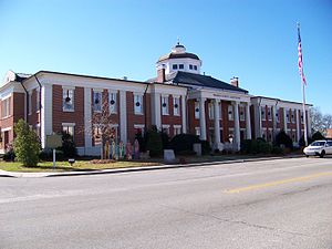
 Warren County courthouse in Warrenton | |
 Location within the U.S. state of Georgia | |
 Georgia's location within the U.S. | |
| Coordinates: 33°25′N 82°41′W / 33.41°N 82.68°W | |
| Country | |
| State | |
| Founded | December 19, 1793 |
| Named for | Joseph Warren |
| Seat | Warrenton |
| Largest city | Warrenton |
| Area | |
| • Total | 287 sq mi (740 km2) |
| • Land | 284 sq mi (740 km2) |
| • Water | 2.4 sq mi (6 km2) 0.8% |
| Population (2020) | |
| • Total | 5,215 |
| • Density | 21/sq mi (8/km2) |
| Time zone | UTC−5 (Eastern) |
| • Summer (DST) | UTC−4 (EDT) |
| Congressional district | 12th |
| Website | www |
Warren County is a county located in the U.S. state of Georgia. As of the 2020 United States census, the population was 5,215, a decrease from 2010. The county seat is Warrenton.[1] The county was created on December 19, 1793, and is named after General Joseph Warren, who was killed in the Battle of Bunker Hill.[2]
- ^ "Find a County". National Association of Counties. Retrieved June 7, 2011.
- ^ "Welcome to Warren County Georgia Chamber of Commerce". Warren County Chamber of Commerce. Retrieved May 6, 2013.
© MMXXIII Rich X Search. We shall prevail. All rights reserved. Rich X Search