Back مقاطعة واشنطن (رود آيلاند) Arabic واشينطون كاونتى (رود ايلاند) ARZ Washington County, Rhode Island BAR Вашингтон (окръг, Роуд Айланд) Bulgarian ৱাশিংটন কাউন্টি, রোড আইল্যান্ড BPY Washington Gông (Rhode Island) CDO Вашингтон (гуо, Род-Айленд) CE Washington County (kondado sa Tinipong Bansa, Rhode Island) CEB Washington County, Rhode Island Welsh Washington County (Rhode Island) German
Washington County | |
|---|---|
 Former Washington County Courthouse in West Kingston | |
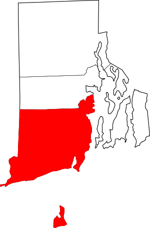
 Location within the U.S. state of Rhode Island | |
 Rhode Island's location within the U.S. | |
| Coordinates: 41°27′16″N 71°34′52″W / 41.454544°N 71.581154°W | |
| Country | |
| State | |
| Founded | June 3, 1729 (Took its current name on October 29, 1781) |
| Named for | George Washington |
| Seat | South Kingstown |
| Largest town | South Kingstown |
| Area | |
| • Total | 563 sq mi (1,460 km2) |
| • Land | 329 sq mi (850 km2) |
| • Water | 234 sq mi (610 km2) 41% |
| Population (2020) | |
| • Total | 129,839 |
| • Density | 830/sq mi (320/km2) |
| Time zone | UTC−5 (Eastern) |
| • Summer (DST) | UTC−4 (EDT) |
| Congressional district | 2nd |
Washington County, known locally as South County, is a county located in the U.S. state of Rhode Island. As of the 2020 census, the population was 129,839.[1] Rhode Island counties have no governmental functions other than as court administrative boundaries, which are part of the state government.[2]
- ^ "Census - Geography Profile: Washington County, Rhode Island". United States Census Bureau. Retrieved November 20, 2021.
- ^ "National Associations of Counties listing for Washington County, Rhode Island". naco.org. Archived from the original on May 7, 2003. Retrieved May 6, 2018.
© MMXXIII Rich X Search. We shall prevail. All rights reserved. Rich X Search