Back مقاطعة واشنطن (يوتا) Arabic واشينطون كاونتى (يوتا) ARZ Washington County, Utah BAR Вашынгтон (акруга, Юта) Byelorussian Уошингтън (окръг) Bulgarian ৱাশিংটন কাউন্টি, ইউটা BPY Washington Gông (Utah) CDO Вашингтон (гуо, Юта) CE Washington County (kondado sa Tinipong Bansa, Utah) CEB Washington County (Utah) Czech
Washington County | |
|---|---|
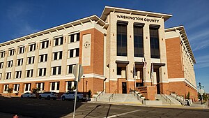
 Washington County administration building, November 2023 | |
 Location within the U.S. state of Utah | |
 Utah's location within the U.S. | |
| Coordinates: 37°17′N 113°31′W / 37.28°N 113.52°W | |
| Country | |
| State | |
| Founded | March 3, 1852 |
| Named for | George Washington |
| Seat | St. George |
| Largest city | St. George |
| Area | |
| • Total | 2,430 sq mi (6,300 km2) |
| • Land | 2,426 sq mi (6,280 km2) |
| • Water | 3.6 sq mi (9 km2) 0.1% |
| Population (2020) | |
| • Total | 180,279 |
| • Density | 74/sq mi (29/km2) |
| Time zone | UTC−7 (Mountain) |
| • Summer (DST) | UTC−6 (MDT) |
| Congressional district | 2nd |
| Website | www |


Washington County is a county in the southwestern corner of Utah, United States.[1] As of the 2020 United States Census, the population was 180,279,[2] making it the fifth-most populous county in Utah. Its county seat and largest city is St. George.[1][3] The county was created in 1852 and organized in 1856.[1][4] It was named after the first President of the United States, George Washington.[1] A portion of the Paiute Indian Reservation is in western Washington County. Washington County comprises the St. George, UT Metropolitan Statistical Area.[1]
- ^ a b c d e "Washington County". Washington County History Wiki. July 20, 2023. Retrieved July 20, 2023.
- ^ "State & County QuickFacts". United States Census Bureau. Retrieved October 25, 2021.
- ^ "Find a County". National Association of Counties. Retrieved June 7, 2011.
- ^ "Utah: Individual County Chronologies". Utah Atlas of Historical County Boundaries. Newberry Library. 2008. Archived from the original on March 6, 2016. Retrieved June 26, 2015.
© MMXXIII Rich X Search. We shall prevail. All rights reserved. Rich X Search