Back نهر واشيتا Arabic نهر واشيتا ARZ Washita River CEB Hoóxe'eo'hé'e CHY Уошита (юханшыв) CV Washita River Danish Washita River German Washita (rivière) French Washita (rivier) Frisian Washita (elv) NB
| Washita River Ouachita, False Washita | |
|---|---|
 Upper Washita River in Hemphill County, Texas | |
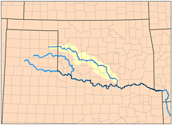
 Map of the Washita River watershed | |
| Location | |
| Country | United States |
| Physical characteristics | |
| Source | |
| • location | Roberts County, Texas |
| • coordinates | 35°37′32″N 100°35′46″W / 35.6256003°N 100.5962467°W[1] |
| • elevation | 3,028 ft (923 m) |
| Mouth | |
• location | Lake Texoma |
• coordinates | 33°54′42″N 96°34′41″W / 33.9117669°N 96.5780504°W[1] |
• elevation | 617 ft (188 m) |
| Length | 295 mi (475 km) |
| Basin size | 7,870 sq mi (20,400 km2) |
| Discharge | |
| • location | Dickson |
| • average | 1,854 cu ft/s (52.5 m3/s)[2] |
| Basin features | |
| River system | Red River |


The Washita River (/ˈwɑːʃɪtɑː/) is a river in the states of Texas and Oklahoma in the United States. The river is 295 miles (475 km) long and terminates at its confluence with the Red River, which is now part of Lake Texoma (33°55′N 96°35′W / 33.917°N 96.583°W) on the Texas–Oklahoma border.
© MMXXIII Rich X Search. We shall prevail. All rights reserved. Rich X Search