| Wayville Adelaide, South Australia | |||||||||||||||
|---|---|---|---|---|---|---|---|---|---|---|---|---|---|---|---|
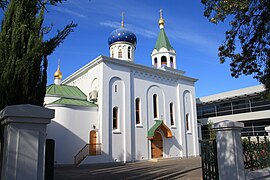
 St. Nicholas Russian Orthodox Church on Greenhill Road | |||||||||||||||
 | |||||||||||||||
| Coordinates | 34°56′42″S 138°35′28″E / 34.945°S 138.591°E | ||||||||||||||
| Population | 1,922 (SAL 2021)[1] | ||||||||||||||
| Established | 1899 | ||||||||||||||
| Postcode(s) | 5034 | ||||||||||||||
| Time zone | ACST (UTC+9:30) | ||||||||||||||
| • Summer (DST) | ACDT (UTC+10:30) | ||||||||||||||
| LGA(s) | City of Unley[2] | ||||||||||||||
| State electorate(s) | Unley | ||||||||||||||
| Federal division(s) | Adelaide | ||||||||||||||
| |||||||||||||||
| |||||||||||||||
Wayville is an inner-southern suburb of Adelaide in the City of Unley. It is most notable for hosting of the Royal Adelaide Show at the Adelaide Showgrounds.
The suburb is bordered to the north by Adelaide's South Parklands,[3] to the west by Adelaide-Goodwood railway line, to the east by King William Road, and to the south by Leader Street, Parsons Street and Simpson Parade. Keswick Creek, a tributary of the Brown Hill Creek and Patawalonga River, flows through the southern side of the suburb.
- ^ Australian Bureau of Statistics (28 June 2022). "Wayville (suburb and locality)". Australian Census 2021 QuickStats. Retrieved 28 June 2022.
- ^ When and Where In Unley: A Chronology 1906 - 2006. Retrieved 11 May 2013.
- ^ The particular sections of the South Park Lands are: Kurrangga, Walyo Yerta, Minno Wirra, and Wikaparndo Wirra
© MMXXIII Rich X Search. We shall prevail. All rights reserved. Rich X Search
