Back Wentworth (rehiyon) CEB Wentworth Shire German Comté de Wentworth French Contea di Wentworth Italian Wentworth Shire Council Dutch Wentworth Shire Swedish
| Wentworth Shire New South Wales | |||||||||||||||
|---|---|---|---|---|---|---|---|---|---|---|---|---|---|---|---|
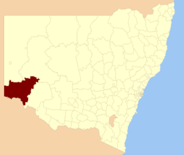
 Location in New South Wales | |||||||||||||||
| Coordinates | 34°05′S 141°54′E / 34.083°S 141.900°E | ||||||||||||||
| Population | 7,453 (LGA 2021)[1] | ||||||||||||||
| • Density | 0.26/km2 (0.67/sq mi) | ||||||||||||||
| Established | 23 January 1879[2] | ||||||||||||||
| Area | 26,269 km2 (10,142.5 sq mi) | ||||||||||||||
| Mayor | Daniel Linklater (Independent) | ||||||||||||||
| Council seat | Wentworth | ||||||||||||||
| Region | Far West | ||||||||||||||
| State electorate(s) | Murray | ||||||||||||||
| Federal division(s) | Farrer | ||||||||||||||
 | |||||||||||||||
| Website | Wentworth Shire | ||||||||||||||
| |||||||||||||||
Wentworth Shire is a local government area in the far south-west Riverina region of New South Wales, Australia. This Shire is located adjacent to the Murray and Darling Rivers. The Shire's major roads are the Sturt and the Silver City Highways. The Shire includes the towns of Wentworth, Buronga, Gol Gol, Dareton and Pooncarie. The shire's namesake is explorer and politician William Wentworth.[3]
The mayor of Wentworth Shire Council is Cr. Daniel Linklater, an Independent politician.
- ^ Australian Bureau of Statistics (28 June 2022). "Wentworth (Local Government Area)". Australian Census 2021 QuickStats. Retrieved 28 June 2022.
- ^ "Wentworth History". Wentworth Shire Council. Retrieved 23 January 2010.
- ^ "Wentworth – A Brief History". Wentworth Shire Council. Archived from the original on 20 May 2024. Retrieved 8 December 2023.
© MMXXIII Rich X Search. We shall prevail. All rights reserved. Rich X Search