Back Wesrand-distriksmunisipaliteit Afrikaans Западен Ранд Bulgarian West Rand District Municipality CEB West Rand District Municipality German West Randi ringkond Estonian District de West Rand French Distrik West Rand ID Municipalità distrettuale di West Rand Italian West Rand Dutch West Rand NOV
West Rand | |
|---|---|
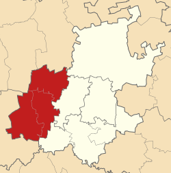
 Location in Gauteng | |
| Coordinates: 26°15′S 27°30′E / 26.250°S 27.500°E | |
| Country | South Africa |
| Province | Gauteng |
| Seat | Randfontein |
| Local municipalities | |
| Government | |
| • Type | Municipal council |
| • Mayor | Thabiso Bovungana (AIC) |
| Area | |
| • Total | 4,087 km2 (1,578 sq mi) |
| Population (2011)[2] | |
| • Total | 820,995 |
| • Density | 200/km2 (520/sq mi) |
| Racial makeup (2011) | |
| • Black African | 79.2% |
| • Coloured | 2.5% |
| • Indian/Asian | 1.1% |
| • White | 16.7% |
| First languages (2011) | |
| • Tswana | 27.3% |
| • Afrikaans | 16.9% |
| • Xhosa | 14.9% |
| • Sotho | 10.8% |
| • Other | 30.1% |
| Time zone | UTC+2 (SAST) |
| Municipal code | DC48 |
The West Rand District Municipality (Tswana: Mmasepala wa Sedika wa West Rand; Afrikaans: Wesrand-distriksmunisipaliteit; Xhosa: uMasipala weSithili sase West Rand; Sotho: Masepala wa Setereke wa West Rand)[1] is one of the districts of the Gauteng province of South Africa, that covers the West Rand area, with the exception of Roodepoort. The seat of the district municipality is Randfontein.[3][4] As of 2011, the most spoken language among its population of 820,995 is Tswana. The district code is CBDC8.
- ^ a b "West Rand District Municipality | Government Communication and Information System (GCIS)". www.gcis.gov.za. Government Communication and Information System. Retrieved 20 June 2017.
- ^ a b c "Statistics by place". Statistics South Africa. Retrieved 27 September 2015.
- ^ "West Rand District Municipality". www.localgovernment.co.za. Yes Media. Retrieved 20 June 2017.
- ^ "West Rand District Municipality Contact". www.wrdm.gov.za. West Rand District Municipality. Retrieved 20 June 2017.
© MMXXIII Rich X Search. We shall prevail. All rights reserved. Rich X Search
