Back West Ryde CEB West Ryde German وست راید (نیو ساوت ولز) Persian West Ryde Malagasy West Ryde, New South Wales Romanian West Ryde Swedish
| West Ryde Sydney, New South Wales | |||||||||||||||
|---|---|---|---|---|---|---|---|---|---|---|---|---|---|---|---|
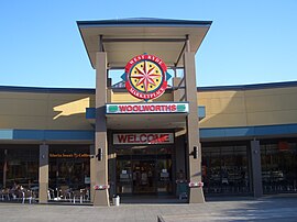
 West Ryde Marketplace | |||||||||||||||
 | |||||||||||||||
| Population | 13,171 (2021 census)[1] | ||||||||||||||
| • Density | 3,689/km2 (9,555/sq mi) | ||||||||||||||
| Postcode(s) | 2114 | ||||||||||||||
| Elevation | 27 m (89 ft) | ||||||||||||||
| Area | 3.57 km2 (1.4 sq mi) | ||||||||||||||
| Location | 15 km (9 mi) north-west of Sydney CBD | ||||||||||||||
| LGA(s) | City of Ryde | ||||||||||||||
| Region | Northern Sydney | ||||||||||||||
| State electorate(s) | Ryde | ||||||||||||||
| Federal division(s) | Bennelong | ||||||||||||||
| |||||||||||||||


West Ryde is a suburb of Sydney, in the state of New South Wales, Australia. West Ryde is located 16 kilometres north-west of the Sydney central business district, in the local government area of the City of Ryde and is part of the Northern Sydney region.
Ryde, North Ryde and East Ryde are separate suburbs. The suburbs of Denistone, Denistone West, Meadowbank and Melrose Park share the 2114 postcode with West Ryde.[2]
- ^ Australian Bureau of Statistics (28 June 2022). "West Ryde". 2021 Census QuickStats. Retrieved 3 February 2024.
- ^ West Ryde Postcode Australia Post
© MMXXIII Rich X Search. We shall prevail. All rights reserved. Rich X Search