Back وست سنکا ، نیویورک AZB West Seneca Catalan West Seneca (condado de Erie) Spanish وست سنکا (حوزه سرشماری)، نیویورک Persian West Seneca (CDP, New York) French West Seneca (CDP), New York Malagasy West Seneca (hrabstwo Erie) Polish Вест-Сенека (сан алу урыны, Нью-Йорк) Tatar Вест-Сенека (переписна місцевість, Нью-Йорк) Ukrainian West Seneca Volapuk
West Seneca, New York | |
|---|---|
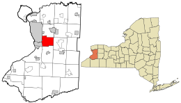
 Location in Erie County and the state of New York | |
| Coordinates: 42°50′21″N 78°45′39″W / 42.83917°N 78.76083°W | |
| Country | United States |
| State | New York |
| County | Erie |
| Town | West Seneca |
| Area | |
| • Total | 21.44 sq mi (55.53 km2) |
| • Land | 21.39 sq mi (55.39 km2) |
| • Water | 0.06 sq mi (0.14 km2) |
| Elevation | 597 ft (182 m) |
| Population (2020) | |
| • Total | 45,500 |
| • Density | 2,127.46/sq mi (821.43/km2) |
| Time zone | UTC-5 (Eastern (EST)) |
| • Summer (DST) | UTC-4 (EDT) |
| Area code | 716 |
| FIPS code | 36-80907[2] |
| GNIS feature ID | 0971949[3] |
| Census | Pop. | Note | %± |
|---|---|---|---|
| 2010 | 44,711 | — | |
| 2020 | 45,500 | 1.8% | |
| U.S. Decennial Census[4] | |||
West Seneca is a hamlet and census-designated place (CDP) in Erie County, New York, United States. The population was 44,711 at the 2010 census. It is part of the Buffalo–Niagara Falls Metropolitan Statistical Area. The CDP corresponds exactly to the area of the town of West Seneca.
- ^ "ArcGIS REST Services Directory". United States Census Bureau. Retrieved September 20, 2022.
- ^ "U.S. Census website". United States Census Bureau. Retrieved January 31, 2008.
- ^ "US Board on Geographic Names". United States Geological Survey. October 25, 2007. Retrieved January 31, 2008.
- ^ "Census of Population and Housing". Census.gov. Retrieved June 4, 2016.
© MMXXIII Rich X Search. We shall prevail. All rights reserved. Rich X Search