| Westmoreland State Park | |
|---|---|
 Potomac River shoreline within Westmoreland State Park | |
| Location | Virginia |
| Nearest city | Montross |
| Coordinates | 38°9′45″N 76°51′58″W / 38.16250°N 76.86611°W |
| Area | 1,321 acres (5.35 km2) |
| Established | June 1936 |
| Governing body | Virginia Department of Conservation and Recreation |
Westmoreland State Park Historic District | |
Virginia Landmarks Register No. 096-0089 | |
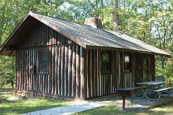
 Cabin 7, one of the original CCC-built cabins in the park | |
| Nearest city | Montross, Virginia |
| Area | 1,321 acres (535 ha) |
| Built | 1933 |
| Architect | Meyers, E.L. Jr.; et al. |
| Architectural style | Late 19th And Early 20th Century American Movements, Modern Movement |
| NRHP reference No. | 05001265[1] |
| VLR No. | 096-0089 |
| Significant dates | |
| Added to NRHP | November 16, 2005 |
| Designated VLR | June 1, 2005[2] |
Westmoreland State Park lies within Westmoreland County, Virginia. The park extends about one and a half miles along the Potomac River and covers 1,321 acres. The Horsehead Cliffs provide visitors with a panoramic view of the Potomac River, and lower levels feature fossils and beach access. The park offers hiking, camping, cabins, fishing, boating and swimming, although mechanical issues have kept the swimming pool closed since 2021.[3] Located on the Northern Neck Peninsula, the park is close to historical sites featuring earlier eras: George Washington's birthplace and Stratford Hall, the birthplace of Robert E. Lee.
- ^ "National Register Information System". National Register of Historic Places. National Park Service. July 9, 2010.
- ^ "Virginia Landmarks Register". Virginia Department of Historic Resources. Retrieved June 5, 2013.
- ^ "Westmoreland State Park". Virginia Department of Conservation and Recreation. Retrieved August 28, 2021.
© MMXXIII Rich X Search. We shall prevail. All rights reserved. Rich X Search


