Back كوبرى ويرلبول رابيدز ARZ Whirlpool Rapids Bridge German Whirlpool Rapids Bridge French 旋涡急流大桥 Chinese
Whirlpool Rapids Bridge | |
|---|---|
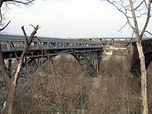
 Whirlpool Rapids Bridge (left) with out-of-service Michigan Central Railway Bridge (far right). A since-removed viaduct of the Niagara Scenic Parkway is also visible in the distance. | |
| Coordinates | 43°06′33″N 79°03′30″W / 43.109208°N 79.058336°W |
| Carries | 2 auto lanes (lower) 1 rail line (upper) |
| Crosses | Niagara River |
| Locale | Niagara Falls, Ontario, and Niagara Falls, New York |
| Named for | Niagara Whirlpool |
| Maintained by | Niagara Falls Bridge Commission Amtrak (rail deck) |
| Characteristics | |
| Design | Arch bridge |
| Total length | 329 metres (1,079.40 ft) |
| Width | 16.9 metres (55.45 ft) (lower) 10 metres (32.81 ft) (upper) |
| Longest span | 167.6 metres (549.87 ft) |
| Clearance above | 3.96 metres (12.99 ft) (lower) |
| Clearance below | 68.6 metres (225.07 ft) |
| History | |
| Opened | 1897 |
| Statistics | |
| Daily traffic | 543 (2006) |
| Toll | Canada-bound only: $5.00 USD per passenger vehicle (via prepaid account linked to NEXUS card or E-ZPass payment)[1] |
| Location | |
 | |
The Whirlpool Rapids Bridge, commonly known as the Whirlpool Bridge or the Lower Steel Arch Bridge (before 1937), is a spandrel braced, riveted, two-hinged arch bridge that crosses the Canada–United States border, connecting the commercial downtown districts of Niagara Falls, Ontario, and Niagara Falls, New York. This bridge is located approximately 1.5 kilometres (0.9 mi) north of the Rainbow Bridge and about 2 kilometres (1.2 mi) from the Falls. It was acquired by the Niagara Falls Bridge Commission in January 1959. Immediately upstream is the similar arch-style Michigan Central Railway Bridge, which has been out of service since 2001.
- ^ "Toll Cost & Vehicle Definitions". Retrieved 2022-08-01.
© MMXXIII Rich X Search. We shall prevail. All rights reserved. Rich X Search