Back Wilkins Township, Pennsylvania Welsh Municipio de Wilkins Spanish Wilkins Township French Wilkins (Pennsylvania) Italian Wilkins Township Dutch Wilkins Township Portuguese Wilkins Township, Pennsylvania Serbo-Croatian Вилкинс Тауншип (Пенсилванија) Serbian Вілкінс Тауншип (округ Аллегені, Пенсільванія) Ukrainian Wilkins Township Uzbek
Wilkins Township | |
|---|---|
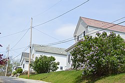
 Houses on Beaver Avenue | |
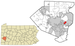
 Location in Allegheny County and state of Pennsylvania | |
| Coordinates: 40°25′22″N 79°49′25″W / 40.42278°N 79.82361°W | |
| Country | United States |
| State | Pennsylvania |
| County | Allegheny |
| Incorporated | November 10, 1821 |
| Government | |
| • Council President | Sylvia Martinelli (D) |
| Area | |
| • Total | 2.75 sq mi (7.11 km2) |
| • Land | 2.75 sq mi (7.11 km2) |
| • Water | 0.00 sq mi (0.00 km2) |
| Population (2010) | |
| • Total | 6,357 |
| • Estimate (2018)[2] | 6,161 |
| • Density | 2,273.59/sq mi (877.89/km2) |
| Time zone | UTC-5 (Eastern (EST)) |
| • Summer (DST) | UTC-4 (EDT) |
| ZIP Codes | 15145, 15235 |
| FIPS code | 42-003-85184 |
Wilkins Township is a township in Allegheny County, Pennsylvania, United States. The population was 6,357 at the 2010 census.[3] It is served by Pennsylvania's 12th congressional district, the 43rd District of the Pennsylvania State Senate, and the 34th District of the Pennsylvania State House of Representatives.
Wilkins Township was named for William Wilkins (1779–1865), a politician from Pennsylvania who served in both houses of Congress and as U.S. Secretary of War.[4]
- ^ "2016 U.S. Gazetteer Files". United States Census Bureau. Retrieved August 13, 2017.
- ^ Bureau, U. S. Census. "U.S. Census website". United States Census Bureau. US Census Bureau. Retrieved December 1, 2019.
- ^ "Race, Hispanic or Latino, Age, and Housing Occupancy: 2010 Census Redistricting Data (Public Law 94-171) Summary File (QT-PL), Wilkins township, Allegheny County, Pennsylvania". United States Census Bureau. Retrieved September 30, 2011.
- ^ Porter, Thomas J. Jr. (May 10, 1984). "Town names carry a little bit of history". Pittsburgh Post-Gazette. p. 1. Retrieved May 26, 2015.
© MMXXIII Rich X Search. We shall prevail. All rights reserved. Rich X Search