| Wisconsin's 35th State Assembly district | |||||
|---|---|---|---|---|---|
2024 map defined in 2023 Wisc. Act 94 2022 map defined in Johnson v. Wisconsin Elections Commission 2011 map was defined in 2011 Wisc. Act 43 | |||||
| Assemblymember |
| ||||
| Demographics | 94.73% White 0.51% Black 1.52% Hispanic 0.78% Asian 1.75% Native American 0.07% Hawaiian/Pacific Islander | ||||
| Population (2020) • Voting age | 59,891 48,377 | ||||
| Website | Official website | ||||
| Notes | Northern Wisconsin | ||||


The 35th Assembly District of Wisconsin is one of 99 districts in the Wisconsin State Assembly.[1] Located in northern Wisconsin, the district comprises all of Lincoln and Langlade counties, and parts of northern Oconto County, northwest Shawano County, southern Oneida County, and northern Marathon County. It includes the cities of Antigo, Merrill, and Tomahawk, and the villages of Aniwa, Eland, Maine, Mattoon, and White Lake. It also contains the Council Grounds State Park and about a quarter of the Nicolet National Forest.[2] The district is represented by Republican Calvin Callahan, since January 2021.[3]
The 35th Assembly district is located within Wisconsin's 12th Senate district, along with the 34th and 36th Assembly districts.[4]
-
 Historic Lincoln County Courthouse in Merrill
 -
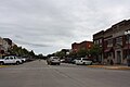 Downtown Tomahawk
 -
 Pine forest within Council Grounds State Park


- ^ "Assembly District 35". Wisconsin Legislature. Retrieved February 1, 2021.
- ^ "Wisconsin Legislative Districts - Assembly District 35 Boundaries". Wisconsin Legislature. Retrieved February 1, 2021.
- ^ "Representative Calvin T. Callahan". Wisconsin Legislature. Retrieved February 1, 2021.
- ^ An Act ... relating to: legislative redistricting (Act 94). Wisconsin Legislature. 2023. Retrieved March 5, 2024.
© MMXXIII Rich X Search. We shall prevail. All rights reserved. Rich X Search