Back ووبورن سندز AZB Woburn Sands (kapital sa distrito) CEB Woburn Sands Welsh Woburn Sands Spanish Woburn Sands Basque ووبورن سندز Persian Woburn Sands French Woburn Sands Irish Woburn Sands Italian Woburn Sands LLD
| Woburn Sands | |
|---|---|
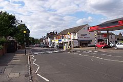
 Woburn Sands High Street | |
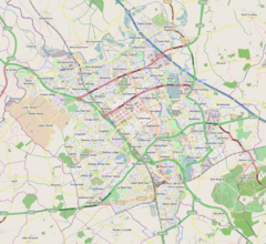
Location within the Milton Keynes urban area Location within Bedfordshire Location within Buckinghamshire | |
| Population | 2,916 (2011 Census)[1] |
| OS grid reference | SP927360 |
| Civil parish |
|
| Unitary authority | |
| Ceremonial county | |
| Region | |
| Country | England |
| Sovereign state | United Kingdom |
| Post town | MILTON KEYNES |
| Postcode district | MK17 |
| Dialling code | 01908 |
| Police | Thames Valley |
| Fire | Buckinghamshire |
| Ambulance | South Central |
| Website | Woburn Sands Town Council |
Woburn Sands (/ˈwoʊbərn/) is a town that straddles the border between Buckinghamshire and Bedfordshire in England, and is part of the Milton Keynes urban area.[2] The larger part of the town is in Woburn Sands civil parish, which is in the City of Milton Keynes,[3] Smaller parts of the town are in the neighbouring parishes of Aspley Guise and Aspley Heath (in Central Bedfordshire).[1] The meandering boundary between Buckinghamshire and Bedfordshire means the Lower and Middle Schools that serve all of the town are both in Aspley Guise CP. Bedfordshire Police and Thames Valley Police both deal with law enforcement issues in the town. At the 2011 Census, the population of the civil parish (only) was 2,916,[1] that of the built-up area (including much of Aspley Guise) was 5,959.[4] Woburn Sands, Aspley Guise and Aspley Heath each has its own centre but together the three settlements are a contiguous built-up area.[1]
- ^ a b c d UK Census (2011). "Local Area Report – Woburn Sands civil parish (E04012196)". Nomis. Office for National Statistics. Retrieved 26 April 2019.
- ^ UK Census (2011). "Local Area Report – Milton Keynes Built-up area (E34005056)". Nomis. Office for National Statistics. Retrieved 29 March 2019. See map.
- ^ "Parishes in Milton Keynes". Milton Keynes Council. Archived from the original on 8 June 2009.
- ^ UK Census (2011). "Local Area Report – Woburn Sands Built-up area sub division (E35000347)". Nomis. Office for National Statistics. Retrieved 1 October 2019.
© MMXXIII Rich X Search. We shall prevail. All rights reserved. Rich X Search


