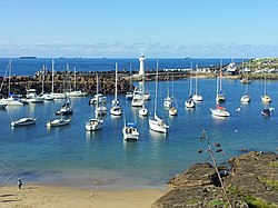
| Wollongong Harbour Precinct | |
|---|---|
 Wollongong Harbour, 2012 | |
| Location | Cliff Road and Endeavour Drive, Wollongong, City of Wollongong, New South Wales, Australia |
| Coordinates | 34°25′16″S 150°54′29″E / 34.4212°S 150.9081°E |
| Built | 1837– |
| Owner | Department of Trade & Investment, Regional Infrastructure & Services |
| Official name | Wollongong Harbour Precinct; Belmore Basin; Government Dam; Government Basin; Stockade Point; Flagstaff Hill; Signal Hill; Brighton Beach; Boat Harbour; Fortress Hill |
| Type | state heritage (landscape) |
| Designated | 5 May 2010 |
| Reference no. | 1823 |
| Type | Port facility |
| Category | Urban Area |
Wollongong Harbour Precinct is a heritage-listed shipping harbour at Cliff Road and Endeavour Drive, in Wollongong, New South Wales, Australia. It was built in 1837. The historic precinct includes Belmore Basin, Government Dam, Government Basin, Stockade Point, Flagstaff Hill, Signal Hill, Brighton Beach, Boat Harbour and Fortress Hill. It was added to the New South Wales State Heritage Register on 5 May 2010.[1]
- ^ "Wollongong Harbour Precinct". New South Wales State Heritage Register. Department of Planning & Environment. H01823. Retrieved 2 June 2018.
 Text is licensed by State of New South Wales (Department of Planning and Environment) under CC-BY 4.0 licence.
© MMXXIII Rich X Search. We shall prevail. All rights reserved. Rich X Search

