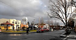
Back وودبورن (أوريغون) Arabic وودبورن، اورقن AZB Удбърн (град, Орегон) Bulgarian Woodburn (Oregon) Catalan Вудбурн (Орегон) CE Woodburn (lungsod sa Tinipong Bansa, Oregon) CEB Woodburn, Oregon Welsh Woodburn (Oregon) German Woodburn (Oregón) Spanish Woodburn (Oregon) Basque
Woodburn | |
|---|---|
| Woodburn, Oregon | |
 | |
 Location in Oregon | |
| Coordinates: 45°08′52″N 122°52′00″W / 45.14778°N 122.86667°W | |
| Country | United States |
| State | Oregon |
| County | Marion |
| Incorporated | 1889 |
| Government | |
| • Mayor | Frank Lonergan |
| Area | |
| • City | 5.86 sq mi (15.17 km2) |
| • Land | 5.86 sq mi (15.17 km2) |
| • Water | 0.00 sq mi (0.00 km2) |
| Elevation | 184 ft (56 m) |
| Population | |
| • City | 26,013 |
| • Density | 4,439.84/sq mi (1,714.36/km2) |
| • Metro | 400,408 |
| Time zone | UTC−8 (Pacific) |
| • Summer (DST) | UTC−7 (Pacific) |
| ZIP Code | 97071 |
| Area code(s) | 503/971 |
| FIPS code | 41-83750[4] |
| GNIS feature ID | 2412296[2] |
| Website | www.woodburn-or.gov |
Woodburn is a city in Marion County, Oregon, United States. Incorporated in 1889, the community had been platted in 1871 after the arrival of the railroad. The city is located in the northern end of the Willamette Valley between Portland and Salem. Interstate 5 connects it to major cities to the north and south. Oregon routes 211, 214, 219, and 99E also serve the city, as do Union Pacific and Willamette Valley Railway freight rail lines.
Woodburn is part of the Salem Metropolitan Statistical Area. With a population of 26,013 at the 2020 census, it is the third-most populous in that metropolitan area after Salem and Keizer.[5]
- ^ "ArcGIS REST Services Directory". United States Census Bureau. Retrieved October 12, 2022.
- ^ a b U.S. Geological Survey Geographic Names Information System: Woodburn, Oregon
- ^ Cite error: The named reference
USCensusDecennial2020CenPopScriptOnlywas invoked but never defined (see the help page). - ^ "U.S. Census website". United States Census Bureau. Retrieved January 31, 2008.
- ^ "QuickFacts". U.S. Census Bureau. Retrieved February 13, 2023.
© MMXXIII Rich X Search. We shall prevail. All rights reserved. Rich X Search
