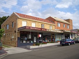
| Woolooware Sydney, New South Wales | |||||||||||||||
|---|---|---|---|---|---|---|---|---|---|---|---|---|---|---|---|
 Wills Road, Woolooware | |||||||||||||||
 | |||||||||||||||
| Coordinates | 34°02′52″S 151°08′28″E / 34.04778°S 151.14111°E | ||||||||||||||
| Population | 3,962 (2016 census)[1] | ||||||||||||||
| Postcode(s) | 2230 | ||||||||||||||
| Elevation | 36 m (118 ft) | ||||||||||||||
| Location | 24 km (15 mi) south of Sydney CBD | ||||||||||||||
| LGA(s) | Sutherland Shire | ||||||||||||||
| State electorate(s) | Cronulla | ||||||||||||||
| Federal division(s) | Cook | ||||||||||||||
| |||||||||||||||
Woolooware is a suburb in southern Sydney, in the state of New South Wales, Australia. Woolooware is located 24 kilometres (15 mi) south of the Sydney central business district in the Sutherland Shire. It shares the 2230 postcode with Cronulla.
Woolooware stretches from Woolooware Bay in the north on the Georges River estuary to Burraneer Bay and Gunnamatta Bay in the south on the Hacking River and Port Hacking estuary. It borders the suburbs of Cronulla, Caringbah, Burraneer and Kurnell.
- ^ Australian Bureau of Statistics (27 June 2017). "Woolooware (State Suburb)". 2016 Census QuickStats. Retrieved 30 October 2017.
© MMXXIII Rich X Search. We shall prevail. All rights reserved. Rich X Search

