Back Rio Xingu Afrikaans نهر شينغو Arabic نهر شينجو ARZ Ríu Xingú AST Şinqu çayı Azerbaijani Шынгу Byelorussian Шынгу BE-X-OLD Шингу Bulgarian শিঙ্গু নদী Bengali/Bangla Riu Xingu Catalan
| Xingu River Rio Xingu (Portuguese) | |
|---|---|
 Xingu River from space, downstream section. | |
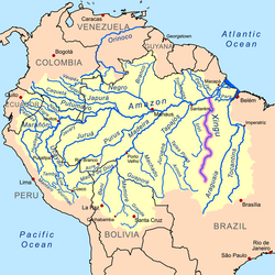
 Map of the Amazon Basin with the Xingu River highlighted | |
| Native name | Byti (Kayapó) |
| Location | |
| Country | Brazil |
| Physical characteristics | |
| Source | Culuene and Sete de Setembro confluence |
| • location | Mato Grosso |
| • coordinates | 12°55′29.7264″S 52°49′33.636″W / 12.924924000°S 52.82601000°W |
| • elevation | 297 m (974 ft) |
| 2nd source | Sete de Setembro |
| • location | Mato Grosso |
| • coordinates | 14°10′13.6956″S 52°45′47.6496″W / 14.170471000°S 52.763236000°W |
| • elevation | 477 m (1,565 ft) |
| 3rd source | Culuene |
| • location | Mato Grosso |
| • coordinates | 14°46′50.0412″S 54°31′7.5324″W / 14.780567000°S 54.518759000°W |
| • elevation | 753 m (2,470 ft) |
| Mouth | Amazon River |
• coordinates | 1°31′37.8012″S 51°52′8.9616″W / 1.527167000°S 51.869156000°W |
• elevation | 0 m (0 ft) |
| Length | 1,640 km (1,020 mi)[1] |
| Basin size | 520,292 km2 (200,886 sq mi) 513,313.5 km2 (198,191.5 sq mi)[2] |
| Discharge | |
| • location | Near mouth, Pará State |
| • average | (Period: 1973–1990)9,680 m3/s (342,000 cu ft/s)[3] (Period: 1971–2000)10,022.6 m3/s (353,940 cu ft/s)[2] |
| Discharge | |
| • location | Altamira, Pará State (Basin size: 449,493 km2 (173,550 sq mi) |
| • average | (Period: 1971–2000)8,345.8 m3/s (294,730 cu ft/s)[2] (Period: 1970–1996)8,665 m3/s (306,000 cu ft/s)[4] |
| Discharge | |
| • location | Belo Horizonte, Pará State (Basin size: 277,265 km2 (107,053 sq mi) |
| • average | (Period: 1971–2000)5,234.1 m3/s (184,840 cu ft/s)[2] (Period: 1970–1996)5,324 m3/s (188,000 cu ft/s)[4] |
| Discharge | |
| • location | São Félix do Xingu, Pará State (Basin size: 250,626 km2 (96,767 sq mi) |
| • average | (Period: 1971–2000)4,660.3 m3/s (164,580 cu ft/s)[2] (Period: 1970–1996)4,627 m3/s (163,400 cu ft/s)[4] |
| Basin features | |
| Progression | Amazon → Atlantic Ocean |
| River system | Amazon |
| Tributaries | |
| • left | Culuene, Curisevo, Tamitatoale, Ronuro, Manissauá-Miçu, Iriri, Pardo, Jaraucu |
| • right | Sete de Setembro, Suia-Miçu, Liberdade, Fresco, Bacaja, Comandante Fontoura River |
The Xingu River (/ʃiːŋˈɡuː/ sheeng-GOO; Portuguese: Rio Xingu, Portuguese pronunciation: [ʃĩˈɡu]; Mẽbêngôkre: Byti, [bɯˈti][5]: 73 ) is a 1,640 km (1,020 mi)[1] river in north Brazil. It is a southeast tributary of the Amazon River and one of the largest clearwater rivers in the Amazon basin,[6] accounting for about 5% of its water.[7]
- ^ a b Ziesler, R.; Ardizzone, G.D. (1979). "Amazon River System". The Inland waters of Latin America. Food and Agriculture Organization of the United Nations. ISBN 92-5-000780-9. Archived from the original on 21 October 2013.
- ^ a b c d e "Amazon".
- ^ Théry, Hervé; Maurence, Pascale (1997). HYDROLOGIE DU BASSIN AMAZONIEN (PDF). ISBN 2-7011-1532-9.
- ^ a b c Michael, T. Coe; Marcos, Heil Costa; Aurélie, Botta; Charon, Birkett (23 August 2002). "Long-term simulations of discharge and floods in the Amazon Basin". CiteSeerX 10.1.1.549.3854.
- ^ Passos, João Lucas Moraes (2018). Caminhos mẽbêngôkre: andando, nomeando, sentando sobre a terra (Ph.D. dissertation). Brasília: Universidade de Brasília.
- ^ Perez, M.S. "Where the Xingu Bends and Will Soon Break". American Scientist. Retrieved 1 October 2017.
- ^ "Waters". Amazon Waters. Archived from the original on 29 June 2018. Retrieved 10 October 2017.
© MMXXIII Rich X Search. We shall prevail. All rights reserved. Rich X Search