Back مقاطعة ياكيما (واشنطن) Arabic Yakima County, Washington BAR Якима (окръг) Bulgarian য়াকিমা কাউন্টি, ৱাশিংটন BPY Yakima Gông (Washington) CDO Якима (гуо, Вашингтон) CE Yakima County CEB Yakima County Czech Yakima County, Washington Welsh Yakima County German
Yakima County | |
|---|---|
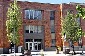
 Yakima County Courthouse | |
 Location within the U.S. state of Washington | |
 Washington's location within the U.S. | |
| Coordinates: 46°28′N 120°44′W / 46.467°N 120.733°W | |
| Country | |
| State | |
| Founded | January 21, 1865 |
| Named for | Yakama Nation |
| Seat | Yakima |
| Largest city | Yakima |
| Area | |
| • Total | 4,311 sq mi (11,170 km2) |
| • Land | 4,295 sq mi (11,120 km2) |
| • Water | 16 sq mi (40 km2) 0.4% |
| Population (2020) | |
| • Total | 256,728 |
| • Estimate (2022) | 257,001 |
| • Density | 58/sq mi (22/km2) |
| Time zone | UTC−8 (Pacific) |
| • Summer (DST) | UTC−7 (PDT) |
| Congressional district | 4th |
| Website | www |
Yakima County is a county in the U.S. state of Washington. As of the 2020 census, its population was 256,728.[1] The county seat and most populous city is Yakima.[2] The county was formed out of Ferguson County in January 1865 and is named for the Yakama tribe of Native Americans.
Yakima County comprises the Yakima, WA Metropolitan Statistical Area and is Washington state's most populous majority-Hispanic county as of 2020.[3]
- ^ "State & County QuickFacts". United States Census Bureau. Retrieved April 21, 2023.
- ^ "Find a County". National Association of Counties. Retrieved June 7, 2011.
- ^ "P2: HISPANIC OR LATINO, AND NOT HISPANIC OR LATINO BY RACE". 2020 Census. United States Census Bureau. Retrieved October 10, 2021.
© MMXXIII Rich X Search. We shall prevail. All rights reserved. Rich X Search