Back يارنيل (أريزونا) Arabic یارنل، آریزونا AZB Yarnell Catalan Ярнелл (Аризона) CE Yarnell CEB Yarnell (Arizona) German Yarnell (Arizona) Spanish Yarnell Estonian Yarnell (Arizona) Basque یارنل، آریزونا Persian
This article contains content that is written like an advertisement. (August 2021) |
Yarnell, Arizona | |
|---|---|
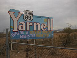
 Sign at entrance to Yarnell | |
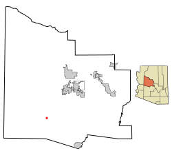
 Location in Yavapai County and the state of Arizona | |
| Coordinates: 34°13′21″N 112°44′59″W / 34.22250°N 112.74972°W | |
| Country | United States |
| State | Arizona |
| County | Yavapai |
| Area | |
| • Total | 8.87 sq mi (22.98 km2) |
| • Land | 8.87 sq mi (22.98 km2) |
| • Water | 0.00 sq mi (0.00 km2) |
| Elevation | 4,780 ft (1,457 m) |
| Population (2020) | |
| • Total | 570 |
| • Density | 64.23/sq mi (24.80/km2) |
| Time zone | UTC-7 (MST) |
| ZIP code | 85362 |
| Area code | 928 |
| FIPS code | 04-84980 |
| GNIS feature ID | 0014039 |
Yarnell is a census-designated place (CDP) in Yavapai County, Arizona, United States. The population of Yarnell was 649 at the 2010 census. Yarnell's economy is based on ranching, mining and services to travelers and retirees. Peeples Valley, three miles north, is closely linked to Yarnell.

- ^ "2020 U.S. Gazetteer Files". United States Census Bureau. Retrieved October 29, 2021.
© MMXXIII Rich X Search. We shall prevail. All rights reserved. Rich X Search
