Back Prato salino del mar Giallo Italian Słona łąka Morza Żółtego Polish Солончакові луки Жовтого моря Ukrainian Sariq dengiz sho'r o'tloqi Uzbek
| Yellow Sea saline meadow | |
|---|---|
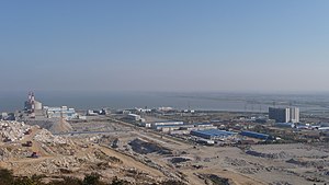
 Northern border of ecoregion, in distance across the bay from Tianwan Nuclear Power Plant | |
 Ecoregion territory (in purple) | |
| Ecology | |
| Realm | Palearctic |
| Biome | Flooded grasslands and savannas |
| Geography | |
| Area | 2,000 km2 (770 sq mi) |
| Countries | China |
| Coordinates | 33°15′N 120°15′E / 33.250°N 120.250°E |
The Yellow Sea saline meadow ecoregion (WWF ID: PA0908) covers a thin strip of wetlands between the Shandong Peninsula and the mouth of the Yangtze River on the coast of the East China Sea. The plants of the region are adapted to the wet, saline soils transitioning inland to fresh water arriving from the west. The area is an important stop-over on the East Asian–Australasian Flyway. The region is under heavy ecological pressure from human development and agriculture.[1][2]
- ^ "Yellow Sea saline meadow". World Wildlife Federation. Retrieved February 23, 2020.
- ^ "Map of Ecoregions 2017". Resolve, using WWF data. Retrieved September 14, 2019.
© MMXXIII Rich X Search. We shall prevail. All rights reserved. Rich X Search