Back يوناغوني (أوكيناوا) Arabic يوناجونى ARZ Yonaguni-chō CEB یوناگونید (اوکیناوا) Persian Yonaguni (Okinawa) French Yonaguni, Okinawa ID Yonaguni (Okinawa) Italian 与那国町 Japanese 요나구니정 Korean Yonaguni, Okinawa Malay
Yonaguni
与那国町 Dunan | |
|---|---|
Town | |
Yonaguni Montage | |
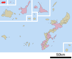
 Location of Yonaguni in Okinawa Prefecture | |
| Coordinates: 24°28′5″N 123°0′17″E / 24.46806°N 123.00472°E | |
| Country | Japan |
| Region | Kyushu (Okinawa) |
| Prefecture | Okinawa Prefecture |
| District | Yaeyama |
| Government | |
| • Mayor | Shukichi Hokama |
| Area | |
| • Total | 28.95 km2 (11.18 sq mi) |
| Population (October 1, 2016) | |
| • Total | 2,048 |
| • Density | 58.2/km2 (151/sq mi) |
| Time zone | UTC+09:00 (JST) |
| City hall address | 129 Aza-Yonaguni, Yonaguni-chō, Yaeyama-gun, Okinawa-ken 907-1801 |
| Climate | Af |
| Website | www |
| Symbols | |
| Bird | Japanese white-eye (Zosterops japonicus) |
| Butterfly | Atlas moth (Attacus atlas) |
| Flower | Lily (Lilium) |
| Tree | Chinese fan palm (Livistona chinensis) |


Yonaguni (与那国町, Yonaguni-chō, Yonaguni: ドゥナン, Dunan, older ジュニ, Juni,[1] Yaeyama: ユノーン, Yunōn, Okinawan: ユナグニ, Yunaguni) is a town located entirely on Yonaguni Island in Yaeyama District, Okinawa Prefecture, Japan. It is the westernmost municipality in Japan, and is known for billfish fishing and as a diving spot. In 1987, divers discovered the Yonaguni Monument, a rock formation that some believe may be man-made.
It is also home to two Ryūkyūan writing systems, pictographic "kaida-di" (also used on Ishigaki and Taketomi islands where it is called "kaida-ji") and the symbols used to indicate family names, "dāhan" (also used on Ishigaki Island where they are called "yāban").
- ^ Vovin 2010, pp. 43–44.
© MMXXIII Rich X Search. We shall prevail. All rights reserved. Rich X Search


