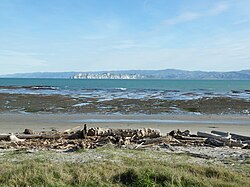
Young Nick's Head / Te Kurī
Te Kuri o Pāoa (Māori) | |
|---|---|
 Young Nick's Head from Kaiti Beach | |
| Coordinates: 38°45′27″S 177°58′16″E / 38.7575°S 177.9712°E | |
| Location | Tūranganui-a-Kiwa / Poverty Bay, New Zealand |
| Native name | Te Kuri o Pāoa (Māori) |
Young Nick's Head / Te Kurī is a headland at the southern end of Tūranganui-a-Kiwa / Poverty Bay in New Zealand's North Island. The area is the landing place of the Horouta and Te Ikaroa-a-Rauru waka which carried Māori settlers to the region around 1350 AD.[1] In Māori, the promontory is named Te Kuri o Pāoa (alternatively known as Te Kuri, or Te Kuri a Pawa).[2]
The settlement of Muriwai is located just inland.[3]
- ^ "Captain Cook's Landing Site and Young Nick's Head". Tourism New Zealand. New Zealand Tourism Board. Retrieved 28 May 2016.
- ^ Rāwiri Taonui (22 September 2012). "Ngā waewae tapu – Māori exploration - The East Coast". Te Ara - the Encyclopedia of New Zealand. Retrieved 28 May 2016.
- ^ Hariss, Gavin. "Muriwai, Gisborne". topomap.co.nz. NZ Topo Map.
© MMXXIII Rich X Search. We shall prevail. All rights reserved. Rich X Search

