Back يوخاري اسكيبارا Arabic يوخارى اسكيبارا ARZ Yuxarı Əskipara Azerbaijani یوخاری اسکیپارا AZB Йухари Аьскипара CE Yuxarı Əskipara Czech Yuxarı Əskipara German Yujari Askipara Spanish اسکیپاره بالا Persian Yuxarı Əskipara Finnish
Yukhari Askipara
Yuxarı Əskipara | |
|---|---|
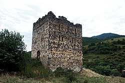
 The fortress at Upper Askipara | |
 | |
| Coordinates: 41°03′58″N 45°01′24″E / 41.06611°N 45.02333°E | |
| Country (de jure) | Azerbaijan |
| • District | Qazakh |
| Country (de facto) | Armenia |
| • Province | Tavush |
| • Municipality | Ijevan |
| Time zone | UTC+4 (AZT) |
 | |
Yukhari Askipara (Azerbaijani: Yuxarı Əskipara, lit. 'Upper Askipara'; Armenian: Վերին Ոսկեպար, romanized: Verin Voskepar, lit. 'Upper Voskepar') is a destroyed village in an exclave of the Qazakh District of Azerbaijan, currently under the control of Azerbaijan and surrounded by the Tavush Province of Armenia. The exclave has been under control by Armenian forces since the First Nagorno-Karabakh War, which also included fighting in Qazakh. Today, the village is destroyed, with only the foundations and some lower portions of the houses remaining.[1]
- ^ Kiesling, Brady; Raffi Kojian (2001). Rediscovering Armenia: an archaeological/touristic gazetteer and map set for the historical monuments of Armenia. Tigran Mets. p. 69. ISBN 9993052280.
© MMXXIII Rich X Search. We shall prevail. All rights reserved. Rich X Search
