| Zaca Fire | |
|---|---|
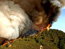
 An active flame front of the fire | |
| Date(s) |
|
| Location | |
| Coordinates | 34°42′57″N 119°46′58″W / 34.7159°N 119.7828°W |
| Statistics[1] | |
| Burned area | 240,207 acres (972 km2) |
| Impacts | |
| Deaths | 0 |
| Non-fatal injuries | 43 |
| Structures destroyed | 1 |
| Damage | $118.3 million (2017 USD) |
| Ignition | |
| Cause | Sparks from a grinding machine on private property |
| Map | |
The Zaca Fire was a wildfire in the San Rafael Mountains, northeast of the Santa Ynez Valley in Santa Barbara County, California. It was the single largest wildfire of the 2007 California wildfire season. The fire started on July 4, 2007, and by August 31, it had burned over 240,207 acres (972.083 km2), making it California's second largest fire in recorded history at that time after the Cedar Fire of 2003.[2][3] As of 2023, it is California's 12th-largest recorded fire in modern history.[4] The fire was contained on September 4, 2007,[5] with the fire being brought under control on October 29, 2007.[6]
- ^ "Zaca Fire Incident Information". CAL FIRE. 4 September 2007. Archived from the original on 3 December 2018. Retrieved 25 August 2015.
- ^ [1] Archived 2015-04-17 at the Wayback Machine Cal Fire update page
- ^ "Zaca Fire information on Yuba net". Archived from the original on 2007-09-01. Retrieved 2007-08-18.
- ^ "Top 20 Largest California Wildfires" (PDF). CAL FIRE. October 24, 2022. Archived from the original (PDF) on January 15, 2021. Retrieved December 4, 2022.
- ^ "Zaca Wildland Fire". Retrieved 2007-09-03.
- ^ Cite error: The named reference
controlledwas invoked but never defined (see the help page).
© MMXXIII Rich X Search. We shall prevail. All rights reserved. Rich X Search

