Back Zeeuws-Vlaanderen Afrikaans فلاندرز الزيلندية Arabic Зеландская Фландрыя Byelorussian Flandrez zelandat Breton Flandes zelandès Catalan Zeeuws-Vlaanderen Danish Zeeuws Vlaanderen German Zelanda Flandrio Esperanto Flandes zelandés Spanish Zeelandar Flandria Basque
This article needs additional citations for verification. (December 2014) |
Zeeuws-Vlaanderen | |
|---|---|
Region | |
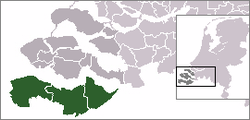
 Location of Zeelandic Flanders in Zeeland, Netherlands | |
| Country | Netherlands |
| Province | Zeeland |
| Municipalities | Sluis Terneuzen Hulst |
| Area | |
| • Total | 875.80 km2 (338.15 sq mi) |
| • Land | 733.19 km2 (283.09 sq mi) |
| • Water | 142.61 km2 (55.06 sq mi) |
| Population (31 December 2010) | 106,522 |
| Major roads | N58, N60, N61, N62 (Western Scheldt Tunnel) |
Preview warning: Page using Template:Infobox settlement with unknown parameter "latitude"
Preview warning: Page using Template:Infobox settlement with unknown parameter "dialling_code"
Preview warning: Page using Template:Infobox settlement with unknown parameter "density"
Preview warning: Page using Template:Infobox settlement with unknown parameter "longitude"
Zeelandic Flanders (Dutch: Zeeuws-Vlaanderen [ˌzeːusˈflaːndərə(n)] ; Zeeuws: Zeêuws-Vlaonderen; West Flemish: Zêeuws-Vloandern)[1] is the southernmost region of the province of Zeeland in the south-western Netherlands. It lies south of the Western Scheldt that separates the region from the remainder of Zeeland and the Netherlands to the north. Zeelandic Flanders is bordered to the south and to the east by Belgium.
- ^ Vlaanderen in isolation: [ˈvlaːndərə(n)].
© MMXXIII Rich X Search. We shall prevail. All rights reserved. Rich X Search
