Back Southampton Afrikaans Southampton AN ساوثهامبتون Arabic ساوثهامبتون ARZ Southampton AST Sauthempton Azerbaijani ساوتهمپتون AZB Саутгемптон Bashkir Саўтгемптан Byelorussian Саўтгэмптан BE-X-OLD
| Unitaire autoriteit in Engeland | |||
|---|---|---|---|

| |||
| Situering | |||
| Land | Engeland | ||
| Status | city | ||
| Regio | South East England | ||
| Coördinaten | 50°54'24"NB, 1°24'16"WL | ||
| Algemeen | |||
| Oppervlakte | 49,9136[1] km² | ||
| Inwoners (2018[2]) |
252.796 (5.065 inw./km²) | ||
| Burgemeester | Alex Houghton | ||
| Overig | |||
| ONS-code | E06000045 | ||
| Website | southampton.gov.uk | ||
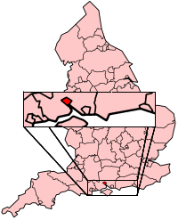
| Detailkaart | |||

| |||
| Foto's | |||

| |||
| De stadspoort Bargate in Southampton | |||
| |||


Southampton is een unitary authority met de officiële titel van city, en het is een district in de Engelse regio South East England, ceremonieel graafschap Hampshire. Southampton telde 252.359 inwoners in 2017. De oppervlakte bedraagt 50 km².
In 2018 was de stad de op twee na grootste havenstad van het land. Londen stond op de eerste plaats qua tonnage (53,2 miljoen ton), gevolgd door haven van Grimsby & Immingham (57,3 miljoen) en Southampton (33,9 miljoen).
- ↑ Office for National Statistics → Download → SAM_for_Administrative_Areas_(2018).zip → SAM_LAD_DEC_2018_UK.xlsx.
- ↑ https://www.ons.gov.uk/file?uri=/peoplepopulationandcommunity/populationandmigration/populationestimates/datasets/populationestimatesforukenglandandwalesscotlandandnorthernireland/mid20182019laboundaries/ukmidyearestimates20182019ladcodes.xls Schatting Office for National Statistics: knop MYE5 → kolom Estimated Population mid-2018]
© MMXXIII Rich X Search. We shall prevail. All rights reserved. Rich X Search
