Back Berlynse Muur Afrikaans Berliner Mauer ALS የበርሊን ግድግዳ Amharic Muro de Berlín AN جدار برلين Arabic سور برلين ARZ Muriu de Berlín AST Berlin divarı Azerbaijani Берлин диуары Bashkir Берлінская сцяна Byelorussian
| Berlin Wall | |
|---|---|
 Berlin Wall, with graffiti and death strip. The side with the graffiti on is the West. This was at a street called Bethaniendamm | |
 | |
| General information | |
| Type | Wall |
| Country | |
| Coordinates | 52°30′58″N 13°22′37″E / 52.51611°N 13.37694°E |
| Construction started | 13 August 1961 |
| Demolished | 9 November 1989 |
| Dimensions | |
| Other dimensions |
|
| Technical details | |
| Size | 155 km (96.3 mi) |
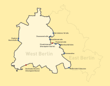
The Berlin Wall (German: Berliner Mauer) was a wall that separated the city of Berlin in Germany from 1961 to 1989. It separated the eastern half from the western half. Many people believed it was a symbol of the Cold War. The Berlin Wall was taken down on November 9, 1989.[1][2] The Berlin Wall was about 168 kilometres (104 miles) long.[3] It was built to prevent people from escaping from the eastern half of Berlin.
- ↑ "Freedom! The Berlin Wall - TIME". time.com. 2011. Archived from the original on 25 August 2013. Retrieved 19 February 2011.
- ↑ "Fall of Communism". future.state.gov. 2011. Archived from the original on 6 July 2015. Retrieved 19 February 2011.
- ↑ Berlin illustrated Newspaper of 3rd October 1990 (special edition), p. 113
© MMXXIII Rich X Search. We shall prevail. All rights reserved. Rich X Search