Back Groot Skeurvallei Afrikaans Val d'o Gran Rift AN الوادي المتصدع الكبير Arabic Gran Valle del Rift AST Böyük Rift Dərəsi Azerbaijani Көнсығыш Африка рифт үҙәне Bashkir Вялікая рыфтавая даліна Byelorussian Вялікая рыфтавая даліна BE-X-OLD Източноафриканска рифтова долина Bulgarian মহা গ্রস্ত উপত্যকা Bengali/Bangla


The Great Rift Valley or East African Rift is a continuous geographical trench, about 6,440 kilometres (3,700 mi) in length, that runs from northern Syria in Southwest Asia to central Mozambique in East Africa. The rift is bordered by a series of mountains and active volcanoes. It is a site of faults and earthquakes.
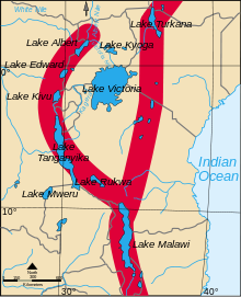
Basically, the western part of Africa is rifting away from the eastern part. This causes all the geological activity at the Valley. Far in the future, a sea will run between these two parts of Africa. The Arabian peninsula is already almost separated. The whole process is part of plate tectonics. In eastern Africa, the valley divides into two, the Western Rift Valley and the Eastern Rift Valley.
There are about 20 UNESCO World Heritage Sites which owe their formation to the geography and geology of the Great Rift Valley.
© MMXXIII Rich X Search. We shall prevail. All rights reserved. Rich X Search