Back Sahara Afrikaans Sahara ALS ሰሐራ በረሓ Amharic Desierto d'o Sahara AN सहारा ANP الصحراء الكبرى Arabic ܨܚܪܐܐ ARC الصحرا الكبرى ARZ চাহাৰা মৰুভূমি Assamese Desiertu d'El Sáḥara AST


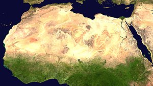
The Sahara,[1] in North Africa, is the largest desert in the world except for Antarctica. The Sahara is the largest hot desert. It is between 4,500 and 5,500 kilometres (2,800 and 3,400 mi) long and between 1,500 and 2,000 kilometres (930 and 1,240 mi) wide.
It is bounded by the Atlantic Ocean, the Atlas Mountains, the Mediterranean Sea, the Red Sea, and the Sahel region. It runs through many countries including Morocco, Algeria, Tunisia, Libya, Egypt, Mauritania, Mali, Niger, Chad, and The Sudan. Most parts are uninhabited, but some people manage to survive in places where there is water.[2]
The Sahara Desert is about 9,200,000 square kilometers (3.6 million square miles) in size. It has been both larger and smaller at different times. After the last ice age it became more fertile, then dried up again. It is the hottest place on the Earth, but not the driest. The driest is the Atacama Desert in South America. The Sahara has about the same size as the whole United States.[3] Since the 1920s, the Sahara had grown by about ten percent, through a process that is known as desertification.[4]
- ↑ Arabic: الصحراء الكبرى, aṣ-ṣaḥrā´ al-kubra, "The Greatest Desert"
- ↑ "Sahara (desert, Africa) -- Britannica Online Encyclopedia". britannica.com. Retrieved 4 May 2010.
- ↑ "The Sahara: Earth's Largest Hot Desert". livescience.com. 2022-02-25. Retrieved 2023-09-21.
- ↑ "New study finds world's largest desert, the Sahara, has grown by 10 percent since 1920". www.nsf.gov. Retrieved 2024-05-05.
© MMXXIII Rich X Search. We shall prevail. All rights reserved. Rich X Search