Back 44.º distrito congresional de California Spanish حوزه انتخابیه چهلوچهارم کالیفرنیا Persian Quarante-quatrième district congressionnel de Californie French 44.º Distrito Congressional da Califórnia Portuguese
| California's 44th congressional district | |||
|---|---|---|---|
Interactive map of district boundaries since January 3, 2023 | |||
| Representative |
| ||
| Area | 105.2 sq mi (272 km2) | ||
| Distribution |
| ||
| Population (2022) | 735,344 | ||
| Median household income | $78,725[1] | ||
| Ethnicity |
| ||
| Cook PVI | D+24[2] | ||
| Created | 1983 | ||
.svg)

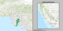
California's 44th congressional district is a congressional district in the U.S. state of California. The district is centered in South Los Angeles and the Los Angeles Harbor Region. It is currently represented by Democrat Nanette Barragán. The 44th district was created as a result of the redistricting cycle after the 1980 census.
The 44th district is composed of these cities and communities: Carson, Compton, East Compton, East Rancho Dominguez, Lakewood, Lynwood, North Long Beach, San Pedro, South Gate, Watts, Walnut Park, West Rancho Dominguez, Willowbrook, and Wilmington.
The congressional district is located in the southern portion of the state and includes part of Los Angeles County.[3] The district's current borders are delineated by the 110 freeway in its western border and takes an inward right following the 105 Freeway. Following S. Central Avenue north, it then zig-zags its way to Florence Ave at its apex. Its eastern border runs mostly along the 710 Freeway until reaching the Pacific Ocean.
- ^ Center for New Media & Promotion (CNMP), US Census Bureau. "My Congressional District". www.census.gov.
- ^ "2022 Cook PVI: District Map and List". Cook Political Report. July 12, 2022. Retrieved January 10, 2023.
- ^ "California's 44th Congressional District - Ballotpedia". Retrieved September 9, 2017.
© MMXXIII Rich X Search. We shall prevail. All rights reserved. Rich X Search