Back Houston Street (Manhattan) Catalan Houston Street Danish Houston Street German Calle Houston (Manhattan) Spanish خیابان هیوستن Persian Houston Street (Manhattan) French רחוב האוסטון HE Houston Street (Manhattan) ID Houston Street Italian ハウストン・ストリート Japanese
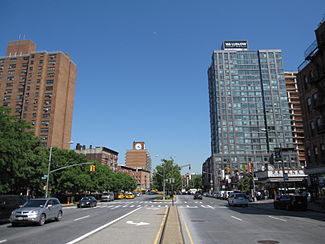
 Looking east from Orchard Street | |
 | |
| Namesake | William Houstoun |
|---|---|
| Length | 2.0 mi (3.2 km) |
| Location | New York |
| ZIP Codes | 10002, 10009, 10012, 10014 |
| West end | |
| East end | |
Houston Street (/ˈhaʊstən/ HOW-stən) is a major east–west thoroughfare in Lower Manhattan in New York City, United States. It runs the full width of the island of Manhattan, from FDR Drive along the East River in the east to the West Side Highway along the Hudson River in the west. The street is divided into west and east sections by Broadway.
Houston Street generally serves as the boundary between neighborhoods on the East Side of Manhattan—Alphabet City, the East Village, NoHo, Greenwich Village, and the West Village to the north; and the Lower East Side, most of the Bowery, Nolita, and SoHo to the south. The numeric street-naming grid in Manhattan, created as part of the Commissioners' Plan of 1811, begins immediately north of Houston Street with 1st Street at Avenue A.[1]
The street's name is pronounced "HOW-stən" ("/ˈhaʊstən/"), in contrast to the city of Houston, Texas, whose name is pronounced "HYOO-stən" ("/ˈhjuːstən/"). The street was named for William Houstoun, whose surname was pronounced "HOW-stən", while the city was named for Sam Houston.[2]
- ^ Cite error: The named reference
Parkswas invoked but never defined (see the help page). - ^ "New York Bookshelf; An Oddly Named Street, A Dark Night, a Gamy Club". The New York Times. February 8, 2004. Retrieved January 19, 2011.
© MMXXIII Rich X Search. We shall prevail. All rights reserved. Rich X Search