Back Prefektur Kanagawa ACE Kanagawa-prefektuur Afrikaans كاناغاوا (محافظة) Arabic كاناجاوا ARZ Prefeutura de Kanagawa AST Kanaqava prefekturası Azerbaijani کاناقاوا اوستانی AZB Préféktur Kanagawa BAN Канагава Byelorussian Канагава (префектура) Bulgarian
This article needs additional citations for verification. (March 2020) |
Kanagawa Prefecture
神奈川県 | |
|---|---|
| Japanese transcription(s) | |
| • Japanese | 神奈川県 |
| • Rōmaji | Kanagawa-ken |
 Minato Mirai 21 commercial area is located between Nishi and Naka districts, Yokohama city, Kanagawa prefecture at sunset. Mount Fuji appears on the horizon | |
| Anthem: Hikari arata ni | |
 | |
| Coordinates: 35°26′51.03″N 139°38′32.44″E / 35.4475083°N 139.6423444°E | |
| Country | |
| Region | Kantō |
| Island | Honshu |
| Capital | Yokohama |
| Subdivisions | Districts: 6, Municipalities: 33 |
| Government | |
| • Governor | Yūji Kuroiwa (since April 2011) |
| Area | |
| • Total | 2,415.83 km2 (932.76 sq mi) |
| • Rank | 43rd |
| Highest elevation | 1,675 m (5,495 ft) |
| Population (October 1, 2015) | |
| • Total | 9,058,094 |
| • Rank | 2nd |
| • Density | 3,770/km2 (9,800/sq mi) |
| • Dialect | Kanagawa dialect |
| GDP | |
| • Total | JP¥ 35,205 billion US$ 323.0 billion (2019) |
| ISO 3166 code | JP-14 |
| Website | www |
| Symbols of Japan | |
| Bird | Common gull (Larus canus) |
| Flower | Golden-rayed lily (Lilium auratum) |
| Tree | Ginkgo (Ginkgo biloba) |

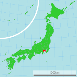
Kanagawa Prefecture (神奈川県, Kanagawa-ken) is a prefecture of Japan located in the Kantō region of Honshu.[2] Kanagawa Prefecture is the second-most populous prefecture of Japan at 9,221,129 (1 April 2022) and third-densest at 3,800 inhabitants per square kilometre (9,800/sq mi). Its geographic area of 2,415 km2 (932 sq mi) makes it fifth-smallest. Kanagawa Prefecture borders Tokyo to the north, Yamanashi Prefecture to the northwest and Shizuoka Prefecture to the west.
Yokohama is the capital and largest city of Kanagawa Prefecture and the second-largest city in Japan, with other major cities including Kawasaki, Sagamihara, and Fujisawa.[3] Kanagawa Prefecture is located on Japan's eastern Pacific coast on Tokyo Bay and Sagami Bay, separated by the Miura Peninsula, across from Chiba Prefecture on the Bōsō Peninsula. Kanagawa Prefecture is part of the Greater Tokyo Area, the most populous metropolitan area in the world, with Yokohama and many of its cities being major commercial hubs and southern suburbs of Tokyo. Kanagawa Prefecture was the political and economic center of Japan during the Kamakura period when Kamakura was the de facto capital and largest city of Japan as the seat of the Kamakura shogunate from 1185 to 1333. Kanagawa Prefecture is a popular tourist area in the Tokyo region, with Kamakura and Hakone being two popular side trip destinations.
- ^ "2020年度国民経済計算(2015年基準・2008SNA) : 経済社会総合研究所 - 内閣府". 内閣府ホームページ (in Japanese). Retrieved 2023-05-18.
- ^ Nussbaum, Louis-Frédéric. (2005). "Kanagawa" in Japan Encyclopedia, p. 466, p. 466, at Google Books; "Kantō" in p. 479, p. 479, at Google Books.
- ^ Nussbaum, "Yokohama" in pp. 1054–1055, p. 154, at Google Books.
© MMXXIII Rich X Search. We shall prevail. All rights reserved. Rich X Search

