Back মরিসভিলে, নর্থ ক্যারোলাইনা Bengali/Bangla Morrisville (Carolina del Nord) Catalan Моррисвилл (Къилбаседа Каролина) CE Morrisville (lungsod sa Tinipong Bansa, North Carolina) CEB Morrisville, Gogledd Carolina Welsh Morrisville (North Carolina) German Morrisville (Carolina del Norte) Spanish Morrisville (Ipar Carolina) Basque موریزویل، کارولینای شمالی Persian Morrisville (Caroline du Nord) French
Morrisville, North Carolina | |
|---|---|
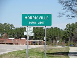
 Morrisville town limit sign | |
| Motto: "Live Connected. Live Well." | |
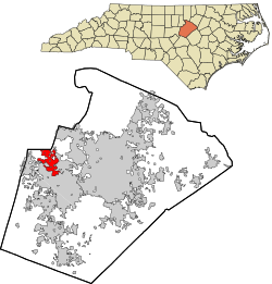
 Location in Wake County and the state of North Carolina. | |
| Coordinates: 35°48′57″N 78°50′21″W / 35.81583°N 78.83917°W | |
| Country | United States |
| State | North Carolina |
| Counties | Wake, Durham |
| Government | |
| • Mayor | T.J. Cawley (Ind.) |
| Area | |
| • Total | 8.89 sq mi (23.02 km2) |
| • Land | 8.83 sq mi (22.86 km2) |
| • Water | 0.06 sq mi (0.16 km2) |
| Elevation | 299 ft (91 m) |
| Population (2020) | |
| • Total | 29,630 |
| • Density | 3,356.75/sq mi (1,296.00/km2) |
| Time zone | UTC−5 (Eastern (EST)) |
| • Summer (DST) | UTC−4 (EDT) |
| ZIP codes | 27519, 27560 |
| Area code | 919 & 984 |
| FIPS code | 37-44520[3] |
| GNIS feature ID | 2406198[2] |
| Website | www |
Morrisville is a town located primarily in Wake County, North Carolina, United States (a small portion extends into neighboring Durham County).[4][5] According to the 2020 census, the population was 29,630.[6] Morrisville is part of the Research Triangle metropolitan region. The regional name originated after the 1959 creation of the Research Triangle Park, located midway between the cities of Raleigh and Durham. The Research Triangle region encompasses the Raleigh-Durham-Cary, NC Combined Statistical Area. The population of the Raleigh-Durham-Cary, NC Combined Statistical Area was 2,106,463 in 2020, while the population of the Raleigh-Cary, NC Metropolitan Statistical Area was 1,413,982 in 2020.[7] The operational headquarters of Lenovo is located in the municipal limits.
- ^ "ArcGIS REST Services Directory". United States Census Bureau. Retrieved September 20, 2022.
- ^ a b U.S. Geological Survey Geographic Names Information System: Morrisville, North Carolina
- ^ "U.S. Census website". United States Census Bureau. Retrieved January 31, 2008.
- ^ "General Information". Town of Morrisville. Archived from the original on June 9, 2011. Retrieved June 16, 2010.
- ^ "P.L. 94-171 County Block Map (2010 Census): Wake County, NC (Map Sheet 17)" (PDF). U.S. Census Bureau. Retrieved December 30, 2011.
- ^ "QuickFacts: Morrisville town, North Carolina". United States Census Bureau. Retrieved January 3, 2023.
- ^ "Metropolitan and Micropolitan Statistical Areas Population Totals and Components of Change: 2020-2021". United States Census Bureau. February 24, 2022. Retrieved August 13, 2022.
© MMXXIII Rich X Search. We shall prevail. All rights reserved. Rich X Search

