Back Sotrabrua Czech Sotrabroen Danish Sotra-Brücke German Puente Sotra Spanish Sotra sild Estonian Pont Sotra French Ponte di Sotra Italian Sotrabrua NN Sotrabrua NB Ponte Sotra Portuguese
Sotra Bridge | |
|---|---|
 | |
| Coordinates | 60°22′21″N 5°09′57″E / 60.37250°N 5.16583°E |
| Carries | Two lanes of National Road 555 |
| Crosses | Knarreviksundet |
| Locale | Bergen and Øygarden, Norway |
| Official name | Sotrabrua |
| Maintained by | Norwegian Public Roads Administration |
| Characteristics | |
| Design | Suspension bridge |
| Total length | 1,236 metres (4,055 ft) |
| Longest span | 468 metres (1,535 ft) |
| Clearance below | 50 metres (160 ft) |
| History | |
| Opened | 11 December 1971 |
| Location | |
 | |
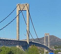
The Sotra Bridge (Norwegian: Sotrabrua) is a suspension bridge which crosses Knarreviksundet between Knarrevik in Øygarden Municipality and Drotningsvik on the mainland of Bergen Municipality in Vestland county, Norway. It carries two road lanes and two narrow pedestrian paths of National Road 555, providing a fixed link for the archipelago of Sotra. The bridge is 1,236 metres (4,055 ft) long, has a main span of 468 metres (1,535 ft) and a clearance of 50 metres (160 ft). In 2007, it had an average 25,494 vehicles per day.
The bridge was brought into use on 11 December 1971, although not officially opened until 1972. It cost 40 million Norwegian krone (NOK) to build, of which NOK 23.5 million was paid for with tolls, which were collected until 1983. When it opened, it was the longest suspension bridge in Norway, but is now the seventh longest. There exist plans to build a second bridge to either expand the road to four lanes, or carry a proposed extension of the Bergen Light Rail. Alternatively, a subsea tunnel could be built to carry a motorway.
© MMXXIII Rich X Search. We shall prevail. All rights reserved. Rich X Search