Back جنوب إيجة Arabic Exéu Meridional AST Cənubi Egey adaları Azerbaijani گونئی اژه اوستانی AZB Паўднёвыя Эгейскія астравы Byelorussian Паўднёвыя Эгейскія астравы BE-X-OLD Южен Егей Bulgarian Egeu Meridional Catalan South Aegean CEB Jižní Egeis Czech
South Aegean
Περιφέρεια Νοτίου Αιγαίου | |
|---|---|
 | |
| Coordinates: 36°48′N 26°12′E / 36.8°N 26.2°E | |
| Country | |
| Decentralized Administration | Aegean |
| Capital | Ermoupoli |
| Largest city | Rhodes |
| Regional units | |
| Government | |
| • Regional governor | Giorgos Hatzimarkos (New Democracy) |
| Area | |
| • Total | 5,286 km2 (2,041 sq mi) |
| Population (2021)[1] | |
| • Total | 324,542 |
| • Density | 61/km2 (160/sq mi) |
| GDP | |
| • Total | €5.976 billion (2021) |
| Time zone | UTC+2 (EET) |
| • Summer (DST) | UTC+3 (EEST) |
| ISO 3166 code | GR-L |
| HDI (2019) | 0.850[3] very high · 10th of 13 |
| Website | www |

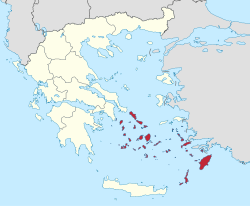
The South Aegean (Greek: Περιφέρεια Νοτίου Αιγαίου, romanized: Periféria Notíou Eyéou, [periˈferia noˈtiu eˈʝeu]) is one of the thirteen administrative regions of Greece. It consists of the Cyclades and Dodecanese island groups in the central and southeastern Aegean Sea.
- ^ "Census 2021 GR" (PDF) (Press release). Hellenic Statistical Authority. 2022-07-19. Retrieved 2022-09-12.
- ^ "Population on 1 January by age, sex and NUTS 2 region", www.ec.europa.eu
- ^ "Sub-national HDI - Area Database". Global Data Lab. Retrieved 2021-07-20.
© MMXXIII Rich X Search. We shall prevail. All rights reserved. Rich X Search
