Back Sunnyvale Afrikaans سانيفال (كاليفورنيا) Arabic سانيفال (كاليفورنيا) ARZ سانیویل، کالیفورنیا AZB Санівейл (Каліфорнія) Byelorussian Сънивейл Bulgarian সানিভেল, ক্যালিফোর্নিয়া Bengali/Bangla Sunnyvale (Califòrnia) Catalan Саннивейл CE Sunnyvale (lungsod sa Tinipong Bansa, California) CEB
This article needs additional citations for verification. (April 2024) |
Sunnyvale | |
|---|---|
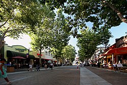
 Downtown Sunnyvale | |
 Location in Santa Clara County and the State of California | |
| Coordinates: 37°22′16″N 122°2′15″W / 37.37111°N 122.03750°W | |
| Country | United States |
| State | California |
| County | Santa Clara |
| Incorporated | December 24, 1912[1] |
| Government | |
| • Type | Council–manager[2] |
| • Mayor | Larry Klein[2] |
| • Vice mayor | Omar Din[2] |
| • City Manager | Kent Steffens[3] |
| Area | |
| • Total | 22.78 sq mi (58.99 km2) |
| • Land | 22.06 sq mi (57.14 km2) |
| • Water | 0.72 sq mi (1.86 km2) 3.09% |
| Elevation | 125 ft (38 m) |
| Population | |
| • Total | 155,805 |
| • Rank | 2nd in Santa Clara County 36th in California |
| • Density | 6,800/sq mi (2,600/km2) |
| Time zone | UTC−8 (PST) |
| • Summer (DST) | UTC−7 (PDT) |
| ZIP codes | 94085–94090 |
| Area codes | 408/669 and 650 |
| FIPS code | 06-77000 |
| GNIS feature IDs | 1656344, 2412009 |
| Website | sunnyvale |
Sunnyvale (/ˈsʌniveɪl, vəl/) is a city located in the Santa Clara Valley in northwest Santa Clara County in the U.S. state of California.
Sunnyvale lies along the historic El Camino Real and Highway 101 and is bordered by portions of San Jose to the north, Moffett Federal Airfield and NASA Ames Research Center to the northwest, Mountain View to the northwest, Los Altos to the southwest, Cupertino to the south, and Santa Clara to the east.
Sunnyvale's population was 155,805 at the 2020 census, making it the second most populous city in the county (after San Jose) and the seventh most populous city in the San Francisco Bay Area.
As one of the major cities that make up California's high-tech area known as Silicon Valley, Sunnyvale is the birthplace of the video game industry, former location of Atari headquarters, and the location of a fictional computer game company in the 1983 film WarGames. Many technology companies are headquartered in Sunnyvale and many more operate there, including several aerospace/defense companies.
Sunnyvale was also the home to Onizuka Air Force Station, often referred to as "the Blue Cube" because of the color and shape of its windowless main building. The facility, previously known as Sunnyvale Air Force Station, was named for the deceased Space Shuttle Challenger astronaut Ellison Onizuka. It served as an artificial satellite control facility of the U.S. military until August 2010 and has since been decommissioned and demolished.
Sunnyvale is one of the few U.S. cities to have a single unified Department of Public Safety, where all personnel are trained as firefighters, police officers, and EMTs, so that they can respond to an emergency in any of the three roles.
Library services for the city are provided by the Sunnyvale Public Library, located at the Sunnyvale Civic Center.
- ^ "California Cities by Incorporation Date". California Association of Local Agency Formation Commissions. Archived from the original (Word) on November 3, 2014. Retrieved August 25, 2014.
- ^ a b c "City Council". City of Sunnyvale. Retrieved October 18, 2020.
- ^ "City Manager's Update Sunnyvale". City of Sunnyvale. Retrieved July 2, 2019.
- ^ "2019 U.S. Gazetteer Files". United States Census Bureau. Retrieved July 1, 2020.
- ^ "Sunnyvale". Geographic Names Information System. United States Geological Survey, United States Department of the Interior. Retrieved December 16, 2014.
- ^ "Sunnyvale (city) QuickFacts". United States Census Bureau.
- ^ "Population and Housing Unit Estimates Tables". United States Census Bureau. Retrieved May 21, 2020.
© MMXXIII Rich X Search. We shall prevail. All rights reserved. Rich X Search

