Back Svinesundský most Czech Svinesundbroen Danish Svinesundbrücke German Svinesunda Ponto Esperanto Puente de Svinesund Spanish پل اسوینسوند Persian Pont de Svinesund French גשר סווינסונד HE Svinesund-híd Hungarian Սվինեսունդի կամուրջ Armenian
Svinesund Bridge | |
|---|---|
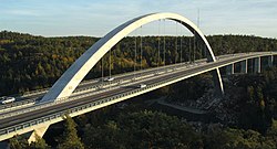
 Svinesund Bridge in October 2005 | |
| Coordinates | 59°05′40″N 11°15′06″E / 59.094497°N 11.251800°E |
| Carries | Four lanes on European route E6 |
| Crosses | Iddefjord at Svinesund |
| Locale | Swedish municipality of Strömstad, Norwegian municipality of Halden |
| Characteristics | |
| Design | Through arch bridge |
| Total length | 704 m (2,310 ft) |
| Width | 2 vehicular lanes in each direction |
| Longest span | 247 m (810 ft) |
| Clearance above | total height 92 m (302 ft) above water |
| Clearance below | deck 55 m (180 ft) above water |
| History | |
| Opened | June 10, 2005 |
| Location | |
 | |

The Svinesund Bridge (Norwegian: Svinesundsbrua, Swedish: Svinesundsbron) is a through arch bridge crossing Iddefjord at Svinesund, and joining Sweden and Norway. Svinesund is a sound separating the Swedish municipality of Strömstad from the Norwegian municipality of Halden, and thus it is the border between Norway and Sweden in this region. The bridge is the westernmost border crossing (and one of the southernmost) between the two countries and carries the European route E6 which is a major traffic route in the area, connecting Oslo and the rest of Norway with Gothenburg, Malmö, Copenhagen and the rest of Europe.
© MMXXIII Rich X Search. We shall prevail. All rights reserved. Rich X Search