Back The Bottom Afrikaans ذي بوتوم Arabic ذى بوتوم ARZ Bottom Azerbaijani Ботам Byelorussian The Bottom BS The Bottom Catalan The Bottom (kapital sa pulo ug munisipyo espesyal) CEB The Bottom Danish The Bottom German
The Bottom | |
|---|---|
 The Bottom, with the campus of the School of Medicine at the bottom right | |
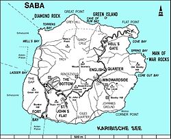
 Map of Saba showing The Bottom | |
| Coordinates: 17°37′34″N 63°14′57″W / 17.62611°N 63.24917°W | |
| Country | |
| Public body | |
| Population (2001)[1] | |
| • Total | 462 |
| Time zone | UTC-4 (AST) |
| Climate | Aw |
The Bottom (formerly Botte) is the capital and largest town of the island of Saba,[2] the Caribbean Netherlands. It is the first stop on the way from Saba's Port in Fort Bay towards the rest of the island. In 2001, it had 462 inhabitants of the total 1,349 islanders.[1] It is the administrative center of Saba.[3]
- ^ a b "Geodata 2001, Saba & Sint.Eustatius, Census 2001". Centraal Bureau voor de Statistiek, Netherlands Antilles. 2001. p. 17. Retrieved 3 May 2021.
- ^ The villages of Saba (Saba Tourist Bureau)
- ^ "About Saba: History and Culture". Saba Tourism. 2018-06-21. Retrieved 2024-01-16.
© MMXXIII Rich X Search. We shall prevail. All rights reserved. Rich X Search


