Back ساحة الاتحاد Arabic ميدان الاتحاد (ميدان فى امريكا) ARZ Юниън Скуеър (Сан Франциско) Bulgarian Union Square (San Francisco) German Plaza Unión Spanish میدان یونیون سان فرانسیسکو Persian Union Square (San Francisco) French Union Square (San Francisco) Italian 유니언 스퀘어 (샌프란시스코) Korean Union Square (San Francisco) Dutch
37°47′17″N 122°24′27″W / 37.78806°N 122.40750°W
Union Square | |
|---|---|
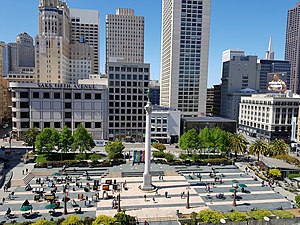
 Overview of the plaza, 2018 | |
| Coordinates: 37°47′17″N 122°24′27″W / 37.788056°N 122.4075°W | |
| Country | United States |
| State | California |
| City | San Francisco |
| Reference no. | 623[1] |
Union Square is a 2.6-acre (1.1-hectare) public plaza bordered by Geary, Powell, Post, and Stockton Streets in downtown San Francisco, California. "Union Square" also refers to the central shopping, hotel, and theater district that surrounds the plaza for several blocks. The area got its name because it was once used for Thomas Starr King rallies and support for the Union Army during the American Civil War,[2] earning its designation as a California Historical Landmark.[1] Despite its declining profile,[3] Union Square in San Francisco is still a major retail hub for the city.
This one-block plaza and surrounding area was historically home to one of the largest collections of department stores, upscale boutiques, gift shops, art galleries, and beauty salons in the United States, making Union Square a major tourist destination and a well-known gathering place in downtown San Francisco.[4] The Dewey Monument is situated at the center of Union Square. It is a statue of Nike, the ancient Greek goddess of victory.
The COVID-19 pandemic in the United States has led to an exodus of companies from Downtown San Francisco, with the Union Square retail district being particularly affected.[5][6] Many retailers have cited high levels of crime, open-air drug use, homelessness, and closed storefronts in the areas around Union Square.[7]
- ^ a b "Union Square". Office of Historic Preservation, California State Parks. Retrieved 2012-10-14.
- ^ Cite error: The named reference
StoryofUnionSquarewas invoked but never defined (see the help page). - ^ King, John (March 3, 2024). "Union Square once was the center of San Francisco. Now it's off the map". San Francisco Chronicle. Retrieved March 9, 2024.
- ^ Lonely Planet Pacific Coast Highways Road Trips. Travel Guide. Lonely Planet Global Limited. 2018. p. pt202. ISBN 978-1-78701-212-7. Retrieved November 4, 2018.
- ^ Avila, Yuri; Blanchard, John (March 8, 2024). "S.F. downtown exodus: Map shows every major retail closure this year". San Francisco Chronicle. Retrieved April 4, 2024.
- ^ Cite error: The named reference
Nguyenwas invoked but never defined (see the help page). - ^ Sam Mauhay-Moore (October 21, 2023). "Walgreens in San Francisco's Union Square to close by next month". Hearst Corporation. Retrieved October 22, 2023.
The store's closure follows that of several retail establishments around Union Square, including Express, Anthropologie, Gap and CB2.
© MMXXIII Rich X Search. We shall prevail. All rights reserved. Rich X Search
