Back خيخه Arabic Хэйхэ Bashkir Háik-ò̤ CDO Heihe (lungsod) CEB Chej-che (prefektura) Czech Heihe Danish Heihe German Χέιχε Greek Heihe Esperanto Heihe Spanish
Heihe
黑河市 Хэйхэ | |
|---|---|
 The Amur River (Heilong Jiang) and Heihe | |
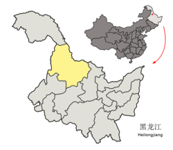
 Location of Heihe City (yellow) in Heilongjiang (light grey) | |
| Coordinates (Heihe Customs): 50°14′24″N 127°31′16″E / 50.2401°N 127.5210°E | |
| Country | People's Republic of China |
| Province | Heilongjiang |
| County-level divisions | 6 |
| Municipal seat | Aihui District |
| Government | |
| • Type | Prefecture-level city |
| • CPC Heihe Secretary | Liu Gang (刘刚) |
| • Mayor | Zhang Enliang (张恩亮) |
| Area | |
| • Prefecture-level city | 54,390 km2 (21,000 sq mi) |
| • Urban | 1,443 km2 (557 sq mi) |
| • Metro | 1,443 km2 (557 sq mi) |
| Population (2020 census)[1] | |
| • Prefecture-level city | 1,286,401 |
| • Density | 24/km2 (61/sq mi) |
| • Urban | 223,832 |
| • Urban density | 160/km2 (400/sq mi) |
| • Metro | 223,832 |
| • Metro density | 160/km2 (400/sq mi) |
| GDP | |
| • Prefecture-level city | CN¥ 44.7 billion US$ 7.2 billion |
| • Per capita | CN¥ 26,518 US$ 4,258 |
| Time zone | UTC+8 (China Standard) |
| Postal code | 164300 |
| Area code | 0456 |
| ISO 3166 code | CN-HL-11 |
| Licence plates | 黑N |
| Climate | Dwb |
| Website | www |
| Heihe | |||||||
|---|---|---|---|---|---|---|---|
 "Heihe", as written in Chinese | |||||||
| Chinese name | |||||||
| Chinese | 黑河 | ||||||
| Literal meaning | black river | ||||||
| |||||||
| Manchu name | |||||||
| Manchu script | ᠰᠠᡥᠠᠯᡳᠶᠠᠨ ᡠᠯᠠ ᡥᠣᡨᠣᠨ | ||||||
| Romanization | Sahaliyan'ula hoton | ||||||
| Russian name | |||||||
| Russian | Хэйхэ | ||||||
| Aigun | |||||||
|---|---|---|---|---|---|---|---|
| Chinese name | |||||||
| Simplified Chinese | 瑷珲 | ||||||
| Traditional Chinese | 璦琿 | ||||||
| Postal | Aigun | ||||||
| |||||||
| Manchu name | |||||||
| Manchu script | ᠠᡳ᠌ᡥᡡᠨ ᡥᠣᡨᠣᠨ | ||||||
| Romanization | Aigun hoton | ||||||
| Russian name | |||||||
| Russian | Айгунь | ||||||
Heihe (Chinese: 黑河; pinyin: Hēihé; lit. 'Black River'; Russian: Хэйхэ) is a prefecture-level city of northern Heilongjiang province, China, located on the Russian border, on the south bank of the Amur (Heilong) River, across the river from Blagoveshchensk. At the 2020 census, 1,286,401 people lived in the prefecture-level city of whom 223,832 lived in the built-up area (or metro) made of Aihui District.
Heihe marks the northeast terminus of the diagonal Heihe–Tengchong Line, which is sometimes used to divide China into east and west.
- ^ "China: Hēilóngjiāng (Prefectures, Cities, Districts and Counties) - Population Statistics, Charts and Map". Citypopulation.de. Retrieved 28 February 2022.
© MMXXIII Rich X Search. We shall prevail. All rights reserved. Rich X Search

