Back Bangka Belitung ACE بانغكا - بليتونغ Arabic Bangka-Belitung AST بانقکا-بلیتونق آدالاری AZB Kepulauan Bangka Belitung BAN Бангка-Белітунг Byelorussian Бангка Белитунг Bulgarian Bangka-Belitung Catalan Bangka Belitung Gùng-dō̤ CDO Kepulauan Bangka Belitung CEB
This article needs additional citations for verification. (April 2023) |
Bangka Belitung Islands
Kepulauan Bangka Belitung | |
|---|---|
| Province of Bangka Belitung Islands | |
| Nickname: Babel | |
| Motto(s): | |
 | |
| Coordinates: 2°8′S 106°7′E / 2.133°S 106.117°E | |
| Country | |
| Established | 4 December 2000[2] |
| Capital and largest city | Pangkalpinang |
| Government | |
| • Body | Bangka Belitung Islands Provincial Government |
| • Governor | Safrizal Zakaria Ali (Acting) |
| • Vice Governor | Vacant |
| Area | |
| • Total | 16,690.13 km2 (6,444.10 sq mi) |
| • Rank | 30th in Indonesia |
| Highest elevation | 665 m (2,182 ft) |
| Population (mid 2023 estimate)[3] | |
| • Total | 1,511,899 |
| • Rank | 29th in Indonesia |
| • Density | 91/km2 (230/sq mi) |
| Demographics | |
| • Ethnic groups |
|
| • Religion |
|
| • Languages | |
| Time zone | UTC+7 (Indonesia Western Time) |
| HDI | |
| HDI rank | 16th in Indonesia (2022) |
| Website | babelprov |
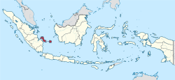
The Bangka Belitung Islands (Indonesian: Kepulauan Bangka Belitung) is a province of Indonesia. Situated off the southeastern coast of Sumatra, the province comprises two main land masses — the islands of Bangka and Belitung — and numerous smaller islands. Bangka Belitung is bordered by the Bangka Strait to the west, the Natuna Sea to the north, the Java Sea is to the south and the Karimata Strait to the east; the two principal islands are separated by the Gaspar Strait, within which lie lesser islands such as Lepar, Pongok (or Liak) and Mendanau.
The province's capital and largest city is Pangkalpinang. The province shares maritime borders with South Sumatra to the west, Riau Islands to the north, Banten, the Special Capital Region of Jakarta, West Java, and Central Java to the south, and West Kalimantan to the east. Bangka Belitung covers a land area of 16,690.13 km2 (6,444.10 sq mi) and had a population of 1,455,678 according to the 2020 census;[6] the official estimate as at mid 2023 was 1,511,899 (comprising 776,607 males and 735,292 females).[3]
Bangka Belitung has an equatorial climate with tropical rainforests, which, however, are disappearing due to deforestation. Mount Maras, located on the island of Bangka, is the province's highest point, with a height of 699 m (2,293 ft). There are several rivers in the province, such as the Sebuku River, Baturusa River and Mendo River. Bangka Belitung is ethnically, culturally and linguistically diverse; major ethnic groups including Malays, Chinese and Javanese. Indonesian is the official language, while the local Malay dialect and Hakka serves as the lingua franca of the province.
Historically, Bangka Belitung has been part of the kingdoms of Sriwijaya, Majapahit and Palembang, before becoming a colony of foreign empires (Dutch, British and Japanese). Bangka Belitung was a residency within the Dutch East Indies. Upon the independence of Indonesia, the region was administered as part of the province of Sumatra and subsequently of South Sumatra. Bangka Belitung officially became the 31st province of Indonesia on 4 December 2000.
- ^ "Lambang Daerah dan Artinya". 10 August 2015.
- ^ "Undang-Undang Republik Indonesia Nomor 27 Tahun 2000" (PDF). dpr.go.id (in Indonesian). People's Representative Council. Archived from the original (PDF) on 27 March 2015. Retrieved 9 March 2020.
- ^ a b Badan Pusat Statistik, Jakarta, 28 February 2024, Provinsi Kepulauan Bangka Belitung Dalam Angka 2024 (Katalog-BPS 1102001.19)
- ^ "Kewarganegaraan, Suku Bangsa, Agama dan Bahasa Sehari-hari Penduduk Indonesia 2010". BPS Indonesia. Retrieved 14 July 2018.
- ^ "Population by Area and Religion of Bangka Belitung 2010" Retrieved 13 July 2018
- ^ Badan Pusat Statistik, Jakarta, 2021.
© MMXXIII Rich X Search. We shall prevail. All rights reserved. Rich X Search

