Back ቸስተር Amharic تشستر Arabic تشيستر ARZ Çester Azerbaijani Чэстэр Byelorussian Честър Bulgarian Chester Breton Chester Catalan Chester (kapital sa kondado sa Hiniusang Gingharian) CEB جێستەر CKB
| Chester | |
|---|---|
| City | |
 Coat of arms | |
Location within Cheshire | |
| Population | 92,742 |
| Demonym | Cestrian |
| OS grid reference | SJ405665 |
| • London | 165 mi (266 km)[1] SE |
| Unitary authority | |
| Ceremonial county | |
| Region | |
| Country | England |
| Sovereign state | United Kingdom |
| Areas of the city | List
|
| Post town | CHESTER |
| Postcode district | CH1–4 |
| Dialling code | 01244 |
| Police | Cheshire |
| Fire | Cheshire |
| Ambulance | North West |
| UK Parliament | |
Chester is a cathedral city and the county town of Cheshire, England, on the River Dee, close to the England-Wales border. With a built up area population of 92,742 in 2021,[2] it is the most populous settlement of Cheshire West and Chester (which had a population of 357,150 in 2021)[3]and serves as its administrative headquarters. It is also the historic county town of Cheshire and the second-largest settlement in Cheshire after Warrington.
Chester was founded in 79 AD as a "castrum" or Roman fort with the name Deva Victrix during the reign of Emperor Vespasian. One of the main army camps in Roman Britain, Deva later became a major civilian settlement. In 689, King Æthelred of Mercia founded the Minster Church of West Mercia, which later became Chester's first cathedral, and the Angles extended and strengthened the walls to protect the city against the Danes. Chester was one of the last cities in England to fall to the Normans, and William the Conqueror ordered the construction of a castle to dominate the town and the nearby Welsh border. Chester was granted city status in 1541.
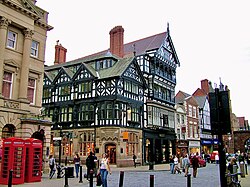
The city walls of Chester are some of the best-preserved in the country and have Grade I listed status. It has a number of medieval buildings, but many of the black-and-white buildings within the city centre are Victorian restorations, originating from the Black-and-white Revival movement.[4] Apart from a 100-metre (330 ft) section, the walls are almost complete.[5] The Industrial Revolution brought railways, canals, and new roads to the city, which saw substantial expansion and development; Chester Town Hall and the Grosvenor Museum are examples of Victorian architecture from this period. Tourism, the retail industry, public administration, and financial services are important to the modern economy. Chester signs itself as Chester International Heritage City on road signs on the main roads entering the city.[6]
- ^ "Coordinate Distance Calculator". boulter.com. Archived from the original on 9 March 2016. Retrieved 8 March 2016.
- ^ "Chester (Cheshire West and Chester, North West England, United Kingdom) - Population Statistics, Charts, Map, Location, Weather and Web Information". www.citypopulation.de. Retrieved 28 April 2024.
- ^ "Cheshire West and Chester (Unitary District, Cheshire West and Chester, United Kingdom) - Population Statistics, Charts, Map and Location". www.citypopulation.de. Retrieved 28 April 2024.
- ^ Pevsner & Hubbard 2003, pp. 130–131
- ^ Cite error: The named reference
m43was invoked but never defined (see the help page). - ^ Morris, C. M., 50th Anniversary of the Historic Towns Studies, 1969 – 2019: Chester, Chester Civic Trust, published September 2019, accessed 10 June 2022
© MMXXIII Rich X Search. We shall prevail. All rights reserved. Rich X Search


