Back Dongjak-gu CEB Dongjak-gu German Dongjak-gu Esperanto Dongjak-gu Spanish Dongjaki ringkond Estonian ناحیه دونگجاک Persian Dongjak-gu French Dongjak (Steedkreis) FRR Tongdzsak-ku Hungarian Distrik Dongjak ID
This article needs additional citations for verification. (July 2021) |
Dongjak
동작구 | |
|---|---|
| 동작구 · 銅雀區 | |
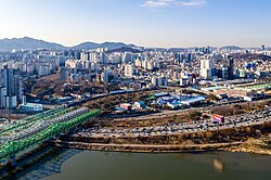
 Views of Dongjak District | |
 Location of Dongjak-gu in Seoul | |
| Coordinates: 37°30′44.65″N 126°56′21.31″E / 37.5124028°N 126.9392528°E | |
| Country | South Korea |
| Region | Sudogwon |
| Special City | Seoul |
| Administrative dong | 15[1] |
| Government | |
| • Body | Dongjak District Council |
| • Mayor | Park Il-ha (People Power Party) |
| • MNAs | List of MNAs |
| Area | |
| • Total | 16.35 km2 (6.31 sq mi) |
| Population (2010[2]) | |
| • Total | 397,317 |
| • Density | 24,000/km2 (63,000/sq mi) |
| Time zone | UTC+9 (Korea Standard Time) |
| Postal code. | 06900 ~ 07199 |
| Area code(s) | +82-2-500,800~ |
| Website | Dongjak-gu official website |
 | |
Dongjak District (Dongjak-gu) is one of the 25 gu that make up the city of Seoul, South Korea. Its name was derived from the Dongjaegi Naruteo Ferry, on the Han River which borders the district to the north. It was the 17th gu created in Seoul, after being separated from Gwanak District on 1 April 1980.[3]
- ^ "Administrative district – area". Dongjak-gu. Archived from the original on 4 March 2016. Retrieved 6 January 2015.
- ^ Korean Statistical Information Service (Korean) > Population and Household > Census Result (2010) > Population by Administrative district, Sex and Age / Alien by Administrative district and Sex Archived 26 August 2013 at the Wayback Machine, Retrieved 2 June 2010.
- ^ "동작구 (Dongjak-gu 銅雀區)" (in Korean). Doosan Encyclopedia. Retrieved 17 April 2008.[permanent dead link]
© MMXXIII Rich X Search. We shall prevail. All rights reserved. Rich X Search
