Back Rechión de Gisborne AN جيهة ݣيزبورن ARY Gisborne AST Distrik Gisborne BAN Гисбърн (регион) Bulgarian Regió de Gisborne Catalan Gisborne (rehiyon) CEB Gisborne District German Gisborne Regiono Esperanto Región de Gisborne Spanish
Gisborne District
Te Tairāwhiti | |
|---|---|
 | |
 Gisborne within the North Island, New Zealand | |
| Coordinates: 38°40′00″S 178°01′00″E / 38.66667°S 178.01667°E | |
| Country | New Zealand |
| Constituted as local authority district | 6 March 1989 |
| Seat | Gisborne |
| Wards | List
|
| Government | |
| • Body | Gisborne District Council |
| • Mayor | Rehette Stoltz |
| Area | |
| • Land | 8,385.29 km2 (3,237.58 sq mi) |
| Population (June 2023)[2] | |
| • Territorial | 52,600 |
| • Urban | 38,200 |
| GDP | |
| • Total | NZ$ 2.690 billion (2021) |
| • Per capita | NZ$ 51,833 (2021) |
| Area code | 06 |
| HDI (2021) | 0.893[4] very high · 15th |
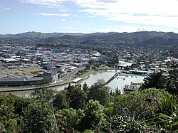
Gisborne District or the Gisborne Region[5] (Māori: Te Tairāwhiti or Te Tai Rāwhiti) is a local government area of northeastern New Zealand. It is governed by Gisborne District Council, a unitary authority (with the combined powers of a district and regional council). It is named after its largest settlement, the city of Gisborne. The region is also commonly referred to as the East Coast.[6]
The region is commonly divided into the East Cape and Poverty Bay. It is bounded by mountain ranges to the west, rugged country to the south, and faces east onto the Pacific Ocean.
- ^ Cite error: The named reference
Areawas invoked but never defined (see the help page). - ^ "Subnational population estimates (RC, SA2), by age and sex, at 30 June 1996-2023 (2023 boundaries)". Statistics New Zealand. Retrieved 25 October 2023. (regional councils); "Subnational population estimates (TA, SA2), by age and sex, at 30 June 1996-2023 (2023 boundaries)". Statistics New Zealand. Retrieved 25 October 2023. (territorial authorities); "Subnational population estimates (urban rural), by age and sex, at 30 June 1996-2023 (2023 boundaries)". Statistics New Zealand. Retrieved 25 October 2023. (urban areas)
- ^ "Regional gross domestic product: Year ended March 2022". Statistics New Zealand. 24 March 2023. Retrieved 4 April 2023.
- ^ "Sub-national HDI – Area Database – Global Data Lab". hdi.globaldatalab.org. Retrieved 18 February 2023.
- ^ Cite error: The named reference
ReorgOrder1989was invoked but never defined (see the help page). - ^ Soutar, Monty (13 July 2012). "East Coast region – Overview". Te Ara – the Encyclopedia of New Zealand. Retrieved 31 May 2014.
© MMXXIII Rich X Search. We shall prevail. All rights reserved. Rich X Search